West Vancouver neighbourhood guide
Westmount, West Vancouver: Homes for Sale, Prices, Schools and Daily Life
Westmount is a hillside neighbourhood of large detached houses in West Vancouver, on the slope between Mathers Avenue and the Upper Levels Highway, above West Bay. On October 11, 2026, every home listed here was a house and 88% of the listings mentioned a view. It suits a buyer who wants a big house on a large lot beside a highway exit, and who will drive to Dundarave or Caulfeild Village for shopping.
For sale now
8
houses, townhouses, duplexes
Asking prices
$2.89M to $8.80M
Middle asking price
$3.97M
West Vancouver detached benchmark
$2.82M
September 2026, GVR
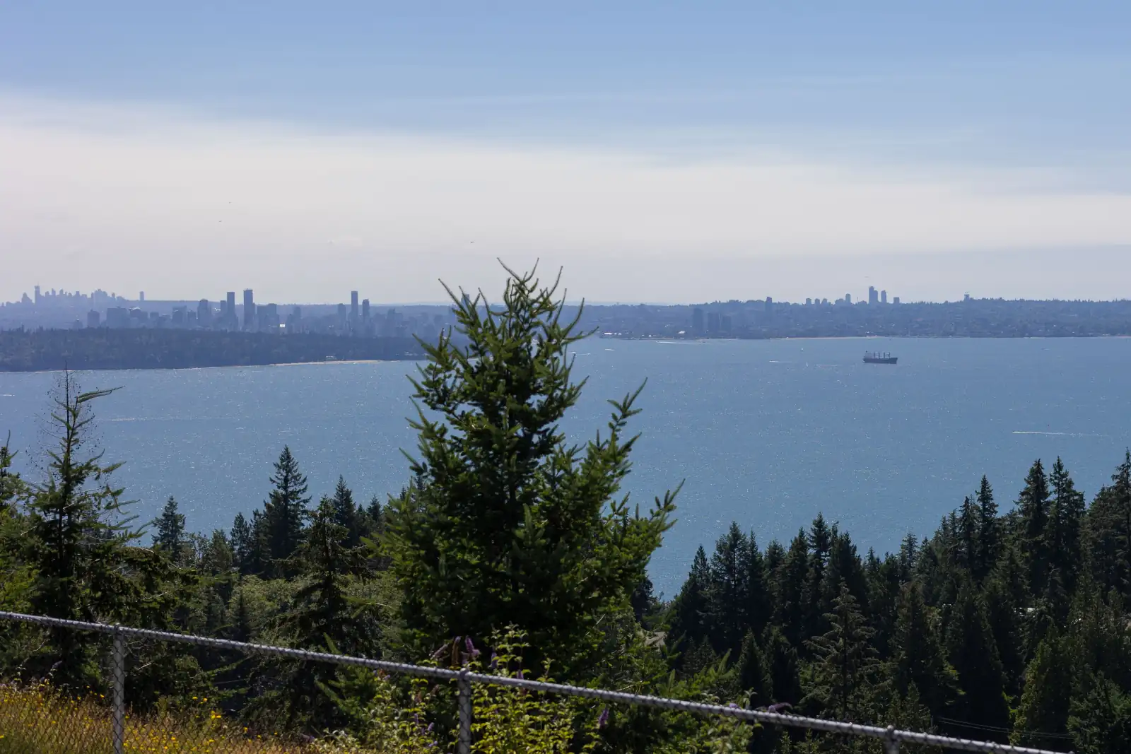
Photo: GoToVan, Wikimedia Commons (cropped), CC BY 4.0
Westmount is in the District of West Vancouver. The province's place name office lists Westmount as a community that is part of the District, under a name it made official on November 26, 1979. On October 11, 2026, 13% of the listings here named West Vancouver on the municipality line and the others left the line blank.
What Westmount is like
The West Vancouver Archives describes Westmount as the land from Benbow Park and West Bay Elementary School in the east to Turner Creek in the west, and from Mathers Avenue up to the Upper Levels Highway. West Bay is the neighbourhood below it. Altamont is to the east and Bayridge is to the west.
Westmount Road is the top street. On OpenStreetMap it runs for 888 metres across the hillside, from Benbow Road to the ramps of highway exit 7. Rockview Place, Westmount Court and Cedaridge Place are short dead-end streets off it. Mathers Avenue is the bottom street. Thompson Crescent leaves Mathers Avenue, climbs the slope and comes back to it farther west, and Benbow Road joins it to Westmount Road.
Every street is on a slope that faces south over the water, and 88% of the listing descriptions here mentioned a view on October 11, 2026. Drive from Mathers Avenue up to Westmount Road to judge the climb yourself.
In our view, Westmount suits a buyer who wants a large house with a view and a short drive to the highway, and who accepts the sound of that highway on the upper streets. A buyer who wants a cafe, a grocery store or a beach at the end of a short level walk will be happier in Dundarave or Ambleside.
Live from the MLS® system
Homes for sale in Westmount
8 houses, townhouses and duplex homes are listed for sale in Westmount today, checked against the MLS® system within the last hour. Condos and apartments are not shown on this page.


Prices
What a home in Westmount costs
Two kinds of numbers, kept apart. The dots are asking prices of the homes listed in Westmount today, counted on this page. The cards are Greater Vancouver REALTORS benchmark prices for all of West Vancouver, which describe a typical home sold anywhere in West Vancouver.
Asking prices today
Each dot is one home for sale. The dark line marks the middle price.
Detached house
$2,822,900
- One year
- down 9.9%
- Ten years
- down 21.9%
West Vancouver benchmark, Greater Vancouver REALTORS, September 2026
All home types
$2,244,700
- One year
- down 7.4%
- Ten years
- down 26.7%
West Vancouver benchmark, Greater Vancouver REALTORS, September 2026
Greater Vancouver REALTORS published no West Vancouver townhouse benchmark in its September 2026 report, so none is shown.
What the homes are like
Every home this page listed in Westmount on October 11, 2026 was a detached house. Only a few homes were listed, so one sale changes each of the shares below. Homes were for sale on Westmount Road, Westmount Place, Rockview Place, Craigend Road, Thompson Crescent, Benbow Road and Mathers Avenue.
The houses are large. The middle house that day had five bedrooms and more than 4,300 square feet of floor space. The middle lot was bigger than 16,000 square feet, which is more than one third of an acre. On the same day, both the middle house and the middle lot here were larger than those in West Bay and Bayridge, and smaller than those in Altamont.
Houses of different ages are mixed together. Of the homes listed that day, 38% had been finished before 1960 and 13% in the 1960s. Another 13% dated from the 1990s, 25% from the 2000s and 13% from the 2020s. The middle year of construction was 1977. In our experience, a buyer here chooses between an original house from the 1950s and a newer, larger house on the same kind of lot.
The listings say little about suites. On that date, 38% of them said the house had no suite and the others left the suite line blank. If you need separate rooms for parents or adult children, ask how the lower floor is laid out before your first visit.
When the homes were built
Year built of the 8 listings that state it.
- Before 19603
- 1960s1
- 1990s1
- 2000s2
- 2020 and later1
Bedrooms
Bedrooms in the 8 listings that state it.
- 31
- 42
- 54
- 6 or more1
Suites: of the 3 houses for sale whose listing states it, 0 list a legal or licensed suite, 0 list a suite the municipality has not approved, and 3 list none. The rest leave the field blank.
The homes listed today have been on the market for 84 days at the middle, counted from each listing date to today. That is how long they have waited so far, which is a different number from how long homes take to sell.
Westmount on the map
- Home for sale
- Public school
- Park
History
How Westmount got its name
A development company chose the name. The West Vancouver Archives records that Martin Corporation Ltd., which developed the subdivision in the 1940s, selected the name Westmount. The record cites the BC Geographical Names Office and the minutes of West Vancouver's council for August 5, 1946.
Air photos held by the archives show the hillside in those years. One is dated June 27, 1940, and another is dated to August 8, 1946, three days after that council meeting. The highway along the top of the neighbourhood came a decade later. According to the archives, the province built the Upper Levels Highway in 1955 and 1956, above most of what was then the built part of West Vancouver.
Houses by known designers were built on Westmount Road in the same years. The District keeps a heritage register, a list of properties it recognizes as having heritage value, and three neighbours on the road are on it. The architect Duncan McNab designed his own house at number 3290, built in 1956, and the register's notes describe a hole cut in the roof so that a tall tree could grow through it. His firm designed the Galloway House at 3350, built in 1957. The Seaton House at 3380, built in 1958, came from Cook's Plan Service, a Vancouver firm that sold ready-made house plans.
The Howell House at 3165 Benbow Road, built in 1959, is on the register as well. On June 27, 1979, the province made two creek names here official, Westmount Creek and Turner Creek, and it records that both flow south into West Bay.
Daily life
Daily life in Westmount
Westmount is a neighbourhood of houses. The map data on this page shows no grocery store, cafe, pharmacy or clinic inside it. The District's community plan lists one local commercial site here, at 3690 Westmount Road, and OpenStreetMap shows a gas station with a small shop at the west end of that road, beside the highway ramps.
The tables on this page name the nearest supermarket and the nearest cafe, and both are in Dundarave. TransLink's schedule gives the 253 bus three to six minutes from Marine Drive at 25th Street, beside the Dundarave shops, to Westmount Road at Rockview Place. The same bus goes on to Caulfeild Drive at Headland Drive, where the Caulfeild Village shopping centre is, four to eight minutes after Rockview Place.
Shops may come closer in time. On November 25, 2024, council approved a plan for Cypress Village, a new community on the land north of the highway. The plan allows up to 3,711 homes and estimates 6,900 residents once the village is complete, in 20 to 25 years. It expects the village centre to include a grocery store and a pharmacy.
OpenStreetMap shows a sidewalk beside Westmount Road from Benbow Road to its west end, and more sidewalk down Benbow Road and Thompson Crescent to Thompson Place, where the school is. It marks Rockview Place, Westmount Place, Westmount Court and Cedaridge Place as having no sidewalk.
Grocery stores
Nearest: IGA, 2.3 km away.
Cafes
Nearest: Delany's Coffee House, 2.5 km away.
Libraries and rec centres
Nearest: West Vancouver Recreation Centre, 3.2 km away.
How far it is
- Downtown Vancouver (Waterfront Station)9.6 km
- Lonsdale Quay and the SeaBus9.9 km
- Lions Gate Hospital10.6 km
- Park Royal shopping centre5.5 km
Places from OpenStreetMap, read October 10, 2026. Distances are in a straight line from the middle of the area, so the trip by road is longer.
Outdoors
Benbow Park, McKechnie Park and the paths above the highway
Benbow Park is on the east edge of Westmount, uphill from West Bay Elementary. OpenStreetMap shows three tennis courts in the park. Beside the school it shows a playground and a gravel soccer field with lights.
McKechnie Park is at the west end of Mathers Avenue. The map shows two tennis courts and two pickleball courts in its upper part, run by the District, with footpaths and steps below them.
The beach is downhill, in West Bay. The table on this page lists West Bay Park and Oxley Street Park, both on the shore below Marine Drive, and the way home from them is a climb.
North of the highway, the District says British Pacific Properties, the landowner, has opened a section of a trail called the Mountain Path between Cypress Bowl Road and the Cypress Pop-Up Village, including a footbridge 200 metres long. OpenStreetMap places the Pop-Up Village 433 metres in a straight line from the west end of Westmount Road, on the far side of the highway, and shows picnic tables, benches and a viewpoint there. The photo at the top of this page was taken at that spot. The District sends visitors to the landowner's website for opening hours and trail closures, so check before you go.
Schools
Schools near Westmount
Westmount is in West Vancouver Schools, which is School District 45. West Bay Elementary stands on the east edge of the neighbourhood, at the end of Thompson Place, and teaches Kindergarten to Grade 7. According to the district, the whole school uses the International Baccalaureate Primary Years Programme, and a preschool for children aged three and four is on the same site.
For high school, the district's page for Rockridge Secondary names West Bay among the areas its families come from. Rockridge teaches Grades 8 to 12 on Headland Drive, across from the Caulfeild Village shopping centre, at the end of the 253 bus route that passes along Westmount Road. West Vancouver Secondary, on Mathers Avenue to the east, is the other public high school in the table on this page.
The table lists two independent schools as well, Mulgrave School on Cypress Bowl Lane, north of the highway, and Collingwood School, and the provincial school list shows elementary and secondary grades at both.
The public school that must take a child depends on the home address, and it can differ from the nearest school. The district's school locator knows Westmount Road, Westmount Place and Westmount Court as street names, and its house number step would not finish for us on October 11, 2026. Look up each house you consider there before you write an offer.
| School | Type | French programs | Distance |
|---|---|---|---|
West Bay Elementary 3175 Thompson Pl, West Vancouver, BC | Public, elementary | None listed | 490 m |
Cypress Park Primary 4355 Marine Dr, West Vancouver, BC | Public, elementary | None listed | 2.0 km |
Irwin Park Elementary 2455 Haywood Ave, West Vancouver, BC | Public, elementary | None listed | 2.3 km |
Caulfeild Elementary 4685 Keith Rd, West Vancouver, BC | Public, elementary | None listed | 3.0 km |
Rockridge Secondary 5350 Headland Dr, West Vancouver, BC | Public, secondary | None listed | 3.1 km |
West Vancouver Secondary 1750 Mathers Ave, West Vancouver, BC | Public, secondary | None listed | 3.6 km |
Mulgrave School 2330 Cypress Bowl Lane, West Vancouver, BC | Independent, elementary-secondary | None listed | 1.3 km |
Collingwood School 70 Morven Dr, West Vancouver, BC | Independent, elementary-secondary | None listed | 1.9 km |
St. Anthony's 595 Keith Rd, West Vancouver, BC | Independent, elementary | None listed | 5.8 km |
Bodwell High School 955 Harbourside Drive, North Vancouver, BC | Independent, secondary | None listed | 8.6 km |
Your address decides your assigned school, which can differ from the closest one. Check any address with the West Vancouver Schools school locator. School list from the BC Ministry of Education, updated October 8, 2026.
Getting around
Getting around
Exit 7 of the Trans-Canada Highway is at the west end of Westmount Road, where the road meets Westridge Avenue and Wentworth Avenue. On OpenStreetMap, the ramp onto the highway toward Vancouver begins at that corner, and the ramp for drivers arriving from Horseshoe Bay ends there. Wentworth Avenue crosses the highway on a bridge to the two ramps on the north side.
The Cypress Village plan expects changes at that corner. It adds a new road, which it calls the Westmount Connector, from Wentworth Avenue at exit 7 up to the village. It also anticipates a traffic signal and lane changes where Westridge Avenue meets Westmount Road, and it gives no date for either.
The 253 bus runs along Westmount Road in one direction, west toward Caulfeild. It comes from Park Royal through Dundarave, turns up 31st Street, and follows Mathers Avenue, Thompson Crescent and Benbow Road to Westmount Road, where it has four stops. TransLink's schedule for September 7, 2026 to January 3, 2027 has 24 trips on a weekday, the first passing Rockview Place at 6:27 a.m. and the last at 10:38 p.m. It gives 14 to 17 minutes from Park Royal. Thirteen trips start in downtown Vancouver, and the four that leave West Georgia Street at Richards Street between 4 and 6 p.m. are given 39 minutes each to reach Rockview Place.
A trip toward Vancouver takes more planning. A 253 that has reached Caulfeild then runs east along Marine Drive, below Westmount. Four morning buses pass Rockview Place between 6:27 and 7:55 a.m., continue as trips to Vancouver, and reach West Georgia Street at Burrard Street 48 to 49 minutes after Rockview Place. Ask the driver whether you may stay on the bus at the end of the line. You can also walk down to Marine Drive for the 250, which is given 30 to 34 minutes from Gables Lane to the same stop on buses that leave between 7 and 9 a.m.
Routes that stop in Westmount
Trips on a regular weekday that stop at one of the 13 stops inside the area, from TransLink's published schedule valid to January 3, 2027.
- 250Horseshoe Bay/Dundarave/Vancouver98 trips
- 253Caulfeild/Vancouver/Park Royal48 trips
Before you buy
Things to check in Westmount
The highway above
By the centre lines on OpenStreetMap, Westmount Road comes within 31 metres of it, Rockview Place within 49 metres, Westmount Court within 69 metres and Cedaridge Place within 76 metres. Craigend Road and Westmount Place are more than 150 metres away, and Mathers Avenue is 301 metres away. Visit at rush hour and listen from the bedrooms and the garden.
The power line
OpenStreetMap maps a power line, labelled 69,000 volts, that runs south from a BC Hydro substation on the north side of the highway. A substation is a fenced yard of electrical equipment. The line crosses Westmount Road beside Rockview Place and runs down the hill to Mathers Avenue at Oxley Street North. Look for the towers and wires from each house you visit, and ask the seller whether the power company holds a legal right to use a strip of the lot.
Three creeks
OpenStreetMap shows three creeks crossing Westmount, each partly open and partly in pipes. Westmount Creek is on the east side, near Benbow Road. Cave Creek comes down the middle, between Craigend Road and Rockview Place. Turner Creek passes Cedaridge Place on the west side. The District's community plan requires a permit for work within 15 metres of the top of a creek bank. Renovating the inside of a house and keeping up an existing garden are exempt.
Trees on a steep lot
West Vancouver's Tree Bylaw defines difficult terrain as land that slopes more than 35% over a height of three metres or more. A permit to cut a protected tree on such land depends on the slope staying stable, and the District may ask for a written opinion from a qualified professional. If a tree expert certifies that a protected tree is an immediate danger, the owner may cut it first. The owner must then report it and apply for a permit within one business day.
The wildfire map
The community plan's wildfire permit area is shaded yellow on a District map, and we could not read that map for single addresses. Inside the area, a new house needs a permit unless a wildfire agreement is already registered on the property's title. The guidelines require the electrical service to a new building to be underground, or on poles that do not burn where that is not possible. Ask the District whether the lot is inside the area, and phone a home insurer with the address before your offer is final.
Houses from the 1950s
On October 11, 2026, 38% of the houses listed here dated from before 1960. Book a full inspection, and ask the District whether the house is on its heritage register. The District's register document says a listing leaves the owner's rights to alter or demolish the house in place, and that council may delay a demolition permit for a time.
Buying
Buying a home in Westmount
Pick a level on the hill first. In our experience, Westmount Road and its side streets have the widest views and the quickest way onto the highway, and they hear the traffic. Mathers Avenue and the lower part of Thompson Crescent are farther from the highway and closer to the school. The railway line through West Bay is 88 metres from those two streets at its nearest point, so listen for trains there.
Then study the lot as carefully as the house. Ask for a survey, walk the driveway, and find out how much of the yard is level. Check the lot against the cards on this page. The price dots show every asking price here today.
Michael Lee works with buyers in Westmount and across West Vancouver. Send the form on this page with your budget, the bedrooms you need and how much a view matters to you. He will reply with the homes that match and set up times to see them.
Selling
Selling a home in Westmount
Few homes are for sale in Westmount at one time, so a buyer who wants the area usually sees all of them. In our experience, the same buyer also tours Altamont, Bayridge and the upper streets of West Bay. The cards on this page count the homes listed here today.
In our experience, buyers here compare four things: the view and whatever could block it, the sound of the highway, the size of the level part of the yard, and the age of the house. Before you list, gather a survey, the District's record of permits and any report on a creek, the slope or the trees. If the power line crosses the lot or the house is on the heritage register, say so in the listing.
Real estate board rules keep sold prices off public pages such as this one. Michael Lee can show you recent Westmount sales in a private price review and explain the list price he would suggest. Use the form on this page to ask for one.
Houses listed
8
$2.89M to $8.80M
Our view
Who buys in Westmount
In our experience, the most common buyer in Westmount is a family with school-age children that wants four or five bedrooms, a view and a short drive to the highway. Many already live on the North Shore and are leaving a smaller home.
In our experience, a second group is parents and adult children who buy one large house together and divide the floors between them. A third group travels often to downtown Vancouver, the Horseshoe Bay ferry or Whistler and wants exit 7 close to home.
Westmount and the areas next to it
Homes listed for sale today, counted on this page.
Questions about Westmount
Is Westmount part of West Vancouver?
Yes. Westmount is a neighbourhood in the District of West Vancouver. The West Vancouver Archives places it between Mathers Avenue and the Upper Levels Highway, above West Bay. Property tax bills and building rules come from the District.
What kind of homes are for sale in Westmount?
On October 11, 2026, every home this page listed in Westmount was a detached house. The middle house had five bedrooms and more than 4,300 square feet of floor space, on a lot bigger than one third of an acre, and 38% of the houses dated from before 1960.
How much does a house in Westmount cost?
The price dots on this page mark the asking price of every Westmount house for sale today and show the middle price. The page also gives the monthly benchmark price for a detached house in West Vancouver, published by Greater Vancouver REALTORS, so you can compare the two.
How did Westmount get its name?
The West Vancouver Archives records that Martin Corporation Ltd., the company that developed the subdivision in the 1940s, selected the name Westmount. Its record cites the minutes of West Vancouver's council for August 5, 1946 and the BC Geographical Names Office.
Which schools serve Westmount?
Westmount is in West Vancouver Schools (School District 45). West Bay Elementary on Thompson Place, on the east edge of the neighbourhood, teaches Kindergarten to Grade 7. Rockridge Secondary and West Vancouver Secondary are the public high schools in the table. Use the district's school locator to confirm the school for an address.
Are there shops in Westmount?
OpenStreetMap shows one, a gas station with a small shop beside the highway ramps. The map data on this page shows no grocery store, cafe, pharmacy or clinic inside Westmount. The nearest supermarket and cafe in the tables are in Dundarave, three to six minutes away on the 253 bus coming home.
How long is the bus ride from Westmount to downtown Vancouver?
TransLink's fall 2026 schedule has four morning 253 buses that pass Westmount Road at Rockview Place between 6:27 and 7:55 a.m. and reach West Georgia Street at Burrard Street 48 to 49 minutes later, by way of Caulfeild. The 250 from Marine Drive at Gables Lane is given 30 to 34 minutes.
Is there a power line in Westmount?
Yes. OpenStreetMap maps a power line, labelled 69,000 volts, from a BC Hydro substation north of the highway across Westmount Road beside Rockview Place and down to Mathers Avenue at Oxley Street North. Look for its towers and wires when you visit.
What is planned north of the highway near Westmount?
Council approved a plan for Cypress Village on November 25, 2024. It allows up to 3,711 homes with shops, built over 20 to 25 years, and adds a road called the Westmount Connector from Wentworth Avenue at exit 7 up to the village. The plan also expects a traffic signal where Westridge Avenue meets Westmount Road.
Are there creek, tree or wildfire rules for homes in Westmount?
Yes. Three creeks cross Westmount, and work within 15 metres of the top of a creek bank needs a permit unless it is exempt. The Tree Bylaw has a rule for protected trees on steep ground. Ask the District whether an address is inside its wildfire permit area.
Is Westmount good for families?
In our view, yes, for a family that drives. The houses are large, an elementary school and two parks with courts are at the edges of the neighbourhood, and the highway exit is close. The drawbacks are the hill, the sound of the highway on the upper streets and the lack of shops.
How do I find out what my Westmount home is worth?
Ask for a price review with the form on this page. Michael Lee will compare your view, your lot and the age of your house with recent Westmount sales and with the houses for sale now. He shares sold prices with you in private, as real estate board rules require.
Who should I talk to about buying or selling in Westmount?
Talk to Michael Lee, REALTOR®, Personal Real Estate Corporation, with eXp Realty, the MultiLiving agent for West Vancouver. Phone him at 604-803-9863 or send the form on this page, and tell him whether you plan to buy, to sell or to do both.
Sources
Written content checked October 11, 2026. Listing numbers counted from the MLS® system on October 12, 2026.
- Westmount (West Vancouver, B.C.): place record with boundaries and origin note (read in an archived list of place records, copy of May 9, 2024), West Vancouver Archives. Read October 11, 2026.
- Archive records tagged Westmount: air photos dated June 27, 1940 and August 8, 1946 (archived copy of February 19, 2024), West Vancouver Archives. Read October 11, 2026.
- Upper Levels Highway (B.C.): place record with origin note (archived copy of May 7, 2024), West Vancouver Archives. Read October 11, 2026.
- 3290 Westmount Road, McNab residence: photograph record, designed by Duncan McNab and built in 1956 (archived copy of May 12, 2024), West Vancouver Archives. Read October 11, 2026.
- Community Heritage Register Supplementary Document, January 2026: what a listing means, and entries for 3290, 3350 and 3380 Westmount Road and 3165 Benbow Road (file last modified January 29, 2026), District of West Vancouver. Read October 11, 2026.
- Westmount (community): official name and location, BC Geographical Names, Government of British Columbia. Read October 11, 2026.
- Westmount Creek: official name and location (flows south into West Bay), BC Geographical Names, Government of British Columbia. Read October 11, 2026.
- Turner Creek: official name and location (flows south into West Bay), BC Geographical Names, Government of British Columbia. Read October 11, 2026.
- Official Community Plan, Schedule ii: Area-Specific Policies and Guidelines (local commercial sites BF-C 8, wildfire NE 1, creeks NE 13, and the Area Development Plan for Cypress Village and Eagleridge, May 2024), District of West Vancouver. Read October 11, 2026.
- Cypress Village Area: plan approved November 25, 2024 and notice of first site work (archived copy of August 22, 2025), District of West Vancouver. Read October 11, 2026.
- Mountain Path and Trestle Bridge (archived copy of April 15, 2026), District of West Vancouver. Read October 11, 2026.
- Tree Bylaw No. 4892, 2016, consolidated to Amendment Bylaw No. 5373, 2025 (difficult terrain, sections 6.2 and 6.3.6), District of West Vancouver. Read October 11, 2026.
- West Bay (IB PYP): grades, program and preschool, West Vancouver Schools. Read October 11, 2026.
- Rockridge: location, grades and the areas its families come from, West Vancouver Schools. Read October 11, 2026.
- Secondary schools (school locator and boundary map links), West Vancouver Schools. Read October 11, 2026.
- TransLink schedule data (GTFS), in effect September 7, 2026 to January 3, 2027, TransLink. Read October 11, 2026.
- MLS® Home Price Index, September 2026 stats package, Greater Vancouver REALTORS. Read October 9, 2026.
- K-12 school locations (school names, addresses and programs), BC Ministry of Education and Child Care, through the BC Data Catalogue. Read October 9, 2026.
- Places, parks and shops, OpenStreetMap contributors (Open Database License). Read October 9, 2026.
- Bus, SeaBus and train schedules (GTFS feed 26SEP_20261009), TransLink. Read October 9, 2026.
General information only. The prices, benchmarks, strata rules, tax and fee figures, lease terms, permit rules and school details on this page are based on the sources and dates listed above. They are not financial, mortgage, tax or legal advice, and not a guarantee of any outcome. Prices, tax rates, fees, municipal rules and school catchments change. Before you buy or sell, confirm each one with its source and speak with a licensed REALTOR®, a mortgage broker and a real estate lawyer.