North Vancouver neighbourhood guide
Deep Cove, North Vancouver: Homes for Sale, Prices, Schools and Daily Life
Deep Cove is a small waterfront village at the eastern edge of the District of North Vancouver, on the shore of Indian Arm. The homes for sale are detached houses of every age, many with a view of the water, and a townhouse is listed occasionally. This page also covers Woodlands and Sunshine, reached by Indian River Drive, and homes farther up Indian Arm that are reached by boat.
For sale now
19
houses, townhouses, duplexes
Asking prices
$689K to $5.18M
Middle asking price
$1.90M
North Vancouver detached benchmark
$2.04M
September 2026, GVR
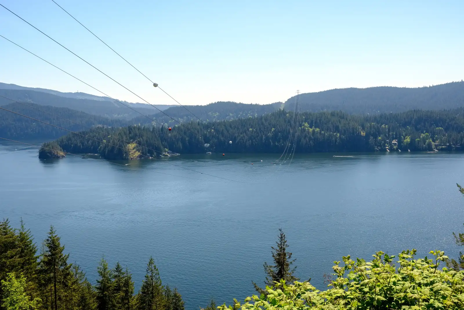
Photo: Xicotencatl, Wikimedia Commons, CC BY-SA 4.0
Deep Cove, Woodlands, Sunshine and the Indian Arm shore on this page are in the District of North Vancouver. Listings here that state a municipality name the District, and many leave the line blank, so confirm it on the property tax notice for each home.
What Deep Cove is like
Deep Cove sits at the eastern edge of the District of North Vancouver. The District describes it as a small village centre that faces the water, with the Seymour area to the west, Burrard Inlet and Indian Arm in front, and the forest of the North Shore mountains behind. Indian Arm is a long, narrow arm of the sea between steep forested slopes. BC Parks gives its length as 18 km.
The village is a few short blocks around Gallant Avenue, which ends near Panorama Park. The District lists galleries, concerts in the park and a small stage theatre among the things people come for, along with trails, shops and paddling or sailing up the Arm. South of the village is Cove Cliff. The Deep Cove Heritage Society says steep slopes made that part hard to settle and that Wickenden Park is its highest point, with houses on the cliffs around it.
This page covers three MLS® area names: Deep Cove, Woodlands-Sunshine-Cascade and Indian Arm. Deep Cove is the village and the streets around it. Woodlands and Sunshine are small groups of homes on the shore north of the village. One road in the District's street data leads to them: Indian River Drive, which starts west of the village and runs northeast through the forest. Homes filed under Indian Arm stand farther up the water, at places such as Brighton Beach, Coldwell Beach and Croker Island. On October 9, 2026, the Brighton Beach listings described that community as reached by water only.
In our view, Deep Cove suits a buyer who wants the sea and the forest close to home and accepts a longer trip to work, to a supermarket and to a hospital. A buyer who wants the SeaBus and many restaurants within a walk will find Lower Lonsdale a closer match.
Live from the MLS® system
Homes for sale in Deep Cove
19 houses, townhouses and duplex homes are listed for sale in Deep Cove today, checked against the MLS® system within the last hour. Condos and apartments are not shown on this page.


Prices
What a home in Deep Cove costs
Two kinds of numbers, kept apart. The dots are asking prices of the homes listed in Deep Cove today, counted on this page. The cards are Greater Vancouver REALTORS benchmark prices for all of North Vancouver, which describe a typical home sold anywhere in North Vancouver.
Asking prices today
Each dot is one home for sale. The dark line marks the middle price.
Detached house
$2,042,000
- One year
- down 6.2%
- Ten years
- up 18.7%
North Vancouver benchmark, Greater Vancouver REALTORS, September 2026
Townhouse
$1,230,400
- One year
- down 4.9%
- Ten years
- up 43.2%
North Vancouver benchmark, Greater Vancouver REALTORS, September 2026
All home types
$1,290,400
- One year
- down 3.9%
- Ten years
- up 16.9%
North Vancouver benchmark, Greater Vancouver REALTORS, September 2026
What the homes are like
Detached houses make up the listings on this page, and a townhouse is listed only occasionally. Condo apartments are sold in the village too, and this page leaves them out. On October 9, 2026, streets with homes listed included Panorama Drive, which runs along the shore north of the village, as well as Deep Cove Road, Caledonia Avenue, Cove Cliff Road, Eastridge Road and Strathcona Road.
The houses come from every period. On that date the listings ranged from houses finished before 1960 to houses finished in the 2020s, the middle year was 1978, and the listings were spread across the decades. A typical house had four bedrooms. The area began as a summer cottage community, so ask when an older house was last updated and what the work covered.
In our experience, a water view or a place on the shore is the largest single factor in price here. On October 9, 2026, two thirds of the listing descriptions mentioned a view and just under half used the word waterfront. Several of the shore houses described a dock.
The homes north of the village are a different purchase. Every listing filed under Indian Arm on that date stated a septic tank, which is a private tank that treats the home's waste water, and none stated public water. The Croker Island listings described power from solar panels and batteries. The group also included a home sold as shares in a co-operative and a home on leased land. A home filed under Deep Cove itself, with a Panorama Drive address, was described as boat access only, so read the access line on every listing.
Few houses here state a suite. On that date most listings left the suite line blank or said none, and the suites that were stated were marked unauthorized, which means the municipality has not approved them.
When the homes were built
Year built of the 18 listings that state it.
- Before 19604
- 1960s2
- 1970s3
- 1980s4
- 1990s1
- 2000s1
- 2010s1
- 2020 and later2
Bedrooms
Bedrooms in the 19 listings that state it.
- 1 or 21
- 38
- 46
- 53
- 6 or more1
Suites: of the 7 houses for sale whose listing states it, 0 list a legal or licensed suite, 2 list a suite the municipality has not approved, and 5 list none. The rest leave the field blank.
The homes listed today have been on the market for 85 days at the middle, counted from each listing date to today. That is how long they have waited so far, which is a different number from how long homes take to sell.
Deep Cove on the map
- Home for sale
- Public school
- Park
History
How Deep Cove began
The District of North Vancouver acknowledges that it stands on the unceded ancestral territories of the Tsleil-Waututh, Squamish and Musqueam peoples. BC Parks describes Indian Arm as the core of Tsleil-Waututh territory and says the Nation has used the land and water of the whole arm for more than a thousand years. Seycove Secondary reports that a Tsleil-Waututh village stood in the part of the area now called Strathcona. In June 2022 the Nation gave the school that village's name, which means "place of good water".
The province's place name office keeps an account from 1927 that calls Deep Cove a settlement and the former wharf of a logging camp. The logging firm left after fires in two summers in a row. The same account says the name is old and came from the depth of the water in the bay. A summer post office called Deep Water opened on May 16, 1927, and it was renamed Deep Cove Post Office on March 22, 1940. Indian Arm was labelled North Arm on a British chart published in 1860. Canada's naming board adopted the present name in 1921.
The Museum and Archives of North Vancouver records that in 1930 Deep Cove was growing as a summer resort with a dance hall, and that the Deep Cove Yacht Club formed in 1936. Mount Seymour Provincial Park was created that same year. The Deep Cove Heritage Society, a volunteer group set up in 1985 by its own account, describes a small community of summer homes from before the Great Depression that became a village as owners updated the cottages and new houses went up.
The society calls Woodlands the first community on the Arm. It attracted settlers in the early 1900s as a summer resort with regattas and water sports, and the summer homes became year-round homes once a road joined them to North Vancouver. The other Indian Arm communities could at first be reached only by water. The society lists Cascade, Sunshine, Brighton Beach, Frames Landing and Thwaytes Landing on the west side of the Arm and says a road later reached some of them.
Daily life
Daily life in Deep Cove
You can walk to coffee, a meal and small shops in the village. The counts on this page show the cafes, the pharmacy and the clinic mapped inside the area. The nearest supermarket on the map is a Safeway on Banff Court in the Parkgate area, outside the village and beside the nearest library and recreation centre. The 211 bus stops on Mount Seymour Parkway at Parkgate Avenue.
Parkgate Library, a branch of the North Vancouver District Public Library, is at 3675 Banff Court. It opens at 10 a.m. every day and closes at 8 p.m. from Tuesday to Thursday and at 6 p.m. on the other four days. The library lists a children's area, a teen space, public computers, a quiet study room and a seating area with a fireplace. Parkgate Community Centre is at 3625 Banff Court. The North Vancouver Recreation and Culture Commission lists a gymnasium with a climbing wall, eight courts for badminton or pickleball and two full basketball courts, along with a pottery studio and rooms for seniors' programs.
The Deep Cove Cultural Centre stands at 4360 Gallant Avenue. The Deep Cove Heritage Society works from the building and keeps photographs, maps and recorded stories of the area. Lions Gate Hospital is in Central Lonsdale, and the table on this page gives the straight line distance to it, to Lonsdale Quay, to Park Royal and to downtown Vancouver.
Life here changes with the season. The District calls Deep Cove a popular destination and tells visitors that street parking in the village is limited and that the parking lots fill early on summer days. Most street parking limits apply from 8 a.m. to 8 p.m. between March 1 and October 31, and some streets are signed for residents only all year. A resident of a signed street can buy a yearly parking permit, which cost $37.62 plus GST for 2026. In our experience, people who live here do their summer weekend errands early in the morning.
Grocery stores
Nearest: Safeway, 1.9 km away.
Cafes
- Cover Neighbourhood Cafe230 m
- Honey Doughnuts & Goodies260 m
- Cove Creek Gallery and Cappuccino Bar310 m
- Deep Cove Caf/Eh330 m
- Cafe Orso360 m
Libraries and rec centres
Nearest: Parkgate Community Centre, 1.9 km away.
How far it is
- Downtown Vancouver (Waterfront Station)12.7 km
- Lonsdale Quay and the SeaBus10.1 km
- Lions Gate Hospital8.7 km
- Park Royal shopping centre13.8 km
Places from OpenStreetMap, read October 9, 2026. Distances are in a straight line from the middle of the area, so the trip by road is longer.
Outdoors
Parks, Quarry Rock and Indian Arm
Two waterfront parks sit beside the village. The District's park data lists Panorama Park, off the 2200 block of Panorama Drive near Gallant Avenue, and Deep Cove Park, off Gallant Avenue, Banbury Road and Rockcliff Road. Deep Cove Park is open from 6 a.m. to 11 p.m. From March 1 to October 31 both parks charge $3 an hour for parking between 8 a.m. and 6 p.m. A District resident can buy a seasonal pass for $10 plus GST that covers one parking session a day at each park. Gallant Creek once ran under Panorama Park in a pipe. It now flows in an open channel there, with a viewing platform behind the cultural centre.
The Baden-Powell Trail leads from Deep Cove through the forest to Quarry Rock, a rock outcrop above Indian Arm. The photo at the top of this page was taken there. On October 6, 2025, District crews began work on sections of rock stairs on the way up. The District limits cars and tour buses in the village partly to protect the land around this trail. A bus of 8,850 kg or more needs a permit to enter Deep Cove, and the fine for coming without one is up to $500.
Boats are part of ordinary life. Gallant Wharf sells places to tie up by the hour from 6 a.m. to 10 p.m., for boats up to 36 feet. Deep Cove is a designated anchorage area, where a visiting boat may tie to one of four buoys for up to 72 hours in a month with a permit that costs $30 a day. Boats on trailers go in at Cates Park/Whey-ah-Wichen, where the launch is open all year. The District and the Tsleil-Waututh Nation have managed that park together under an agreement signed in 2001. The District lists 6 km of waterfront trails, beaches, playgrounds and tennis courts there, and the last stage of work to restore its shoreline was due to start in October 2026.
Two provincial parks begin close by. BC Parks says Mount Seymour Park, established in 1936, has 14 hiking trails, and its entrance is on Mount Seymour Road just north of Mount Seymour Parkway. A free day-use parking pass may be needed there in winter. Say Nuth Khaw Yum Park, also known as Indian Arm Park, protects the shores of the upper Arm. BC Parks says the Tsleil-Waututh Nation and the province manage it together, that the name means "Serpent's Land", and that most visitors arrive by water. It gives a paddling time of four to six hours up the Arm to the camping areas at Bishop Creek or Granite Falls, for experienced paddlers.
Smaller parks serve the streets south of the village. Wickenden Park is a forested park entered from Lockehaven Road, Eastridge Road, Cove Cliff Road and Cardinal Crescent. Myrtle Park, off Deep Cove Road and Banbury Road, is a sports park open from 6 a.m. to 10 p.m. The District also keeps a small public wharf for boating on Strathcona Road.
Schools
Schools in and near Deep Cove
Deep Cove is in the North Vancouver School District. Cove Cliff Elementary on Banbury Road is the public elementary school closest to the middle of the area. The Deep Cove Heritage Society says it opened in 1990 and took the name of the neighbourhood. Dorothy Lynas Elementary and Sherwood Park Elementary are the next closest, and the province's school data lists early French immersion at both.
Seycove Secondary, at 1204 Caledonia Avenue, is the public high school inside the area. The district groups each high school with the elementary schools that lead to it, and its list places Cove Cliff, Dorothy Lynas and Sherwood Park with Seycove. The same list sends French immersion students from Dorothy Lynas and Sherwood Park on to Windsor Secondary. The school's full name is Seycove Secondary at sə́yəmətən, the name the Tsleil-Waututh Nation gave it in 2022.
One local detail for parents: from June 27 to September 7, 2026, the District opened the parking lots at Cove Cliff Elementary and Seycove Secondary to village visitors between 9 a.m. and 10:30 p.m. The table on this page also lists independent schools. A catchment is the set of addresses whose children a public school must accept, and it can differ from the nearest school. Enter the address in the district's school locator before you make an offer.
| School | Type | French programs | Distance |
|---|---|---|---|
Cove Cliff Elementary 1818 Banbury Rd, North Vancouver, BC | Public, elementary | None listed | 280 m |
Dorothy Lynas Elementary 4000 Inlet Cres, North Vancouver, BC | Public, elementary | Early immersion | 1.1 km |
Sherwood Park Elementary 4085 Dollar Rd, North Vancouver, BC | Public, elementary | Early immersion | 2.2 km |
Blueridge Elementary 2650 Bronte Dr, North Vancouver, BC | Public, elementary | None listed | 3.9 km |
Seycove Secondary Community 1204 Caledonia Ave, North Vancouver, BC | Public, secondary | None listed | 870 m |
Windsor Secondary 931 Broadview Dr, North Vancouver, BC | Public, secondary | Early immersion | 3.9 km |
St. Pius X Elementary School 1150 Mt. Seymour Road, North Vancouver, BC | Independent, elementary | None listed | 1.7 km |
Lions Gate Christian Academy 919 Tollcross Rd, North Vancouver, BC | Independent, elementary-secondary | None listed | 3.7 km |
Kenneth Gordon 420 Seymour River Pl, North Vancouver, BC | Independent, elementary-secondary | None listed | 5.3 km |
Brockton Preparatory School 3467 Duval Rd, North Vancouver, BC | Independent, elementary-secondary | None listed | 5.8 km |
Your address decides your assigned school, which can differ from the closest one. Check any address with the North Vancouver School District school locator. School list from the BC Ministry of Education, updated October 8, 2026.
Getting around
Getting around
Two bus routes start in the village. The 211 leaves from Panorama Drive, follows Deep Cove Road and Mount Seymour Parkway to Phibbs Exchange, then crosses to Vancouver and ends at Burrard Station. The 212 leaves from Banbury Road at Gallant Avenue and follows Dollarton Highway to Phibbs Exchange. The table on this page counts the weekday trips on each route.
TransLink's schedule for September 7, 2026 to January 3, 2027 allows 58 to 64 minutes from Panorama Drive at Naughton Avenue to Burrard Station for weekday 211 buses that leave between 7 and 8:30 a.m. The last direct 211 to Burrard Station leaves at 5:45 p.m., and later buses end at Phibbs Exchange. The 212 is given 16 to 18 minutes from the village to Phibbs Exchange for buses that leave between 7:20 and 8:51 a.m. Riders change at Phibbs Exchange for other routes.
Drivers leave by Deep Cove Road, then take Mount Seymour Parkway or Dollarton Highway west to the Second Narrows (Ironworkers Memorial) Bridge. BC Parks puts the nearby Mount Seymour Park entrance 15 km from downtown Vancouver by that route. The bridge is slow at rush hour. In snow, the District aims to have bus routes passable within 12 hours after the snow stops. Local streets come last, within 96 hours.
Woodlands and Sunshine depend on Indian River Drive. In May 2026 the District's fire service ran a full-day exercise that assumed the road was blocked and practised moving residents out by boat. Owners farther up the Arm travel by boat, and the District keeps a long-term pass at Gallant Wharf for residents of Indian Arm only.
Routes that stop in Deep Cove
Trips on a regular weekday that stop at one of the 9 stops inside the area, from TransLink's published schedule valid to January 3, 2027.
- 211Seymour/Phibbs Exchange/Burrard Station89 trips
- 212Dollarton Hwy71 trips
Before you buy
Things to check in Deep Cove
Homes reached by boat
Some homes on this page have no road. The District's fire service describes the Indian Arm communities as partly reachable only by water. Before you visit one, ask how you get there in winter, where you keep a car and a boat, who supplies power and water, and how waste water is treated. Ask the District about the long-term pass at Gallant Wharf, and ask an insurer and a mortgage broker whether they will cover the address.
Docks and the shore
The Vancouver Fraser Port Authority manages the water in front of homes on Burrard Inlet and Indian Arm. Its guideline of November 2024 says an owner needs a project permit and a licence agreement for a private dock, and a permit to repair, upgrade or remove one. In some mapped areas no new dock is allowed. Ask the seller for the dock licence and confirm with the port authority that it can pass to you.
Sea level and waves
The District plans for the sea to rise one metre by 2100 and two metres by 2200. It has finished a study of waves and coastal flooding for the shore from the 2800 block of Dollarton Highway to the north end of the District in Indian Arm, and held a public session on the results on March 12, 2026. Its Creek Hazard rules also apply to waterfront lots exposed to sea level rise, even where the map does not yet show them. Email the District's environment staff about any shore lot.
Creeks
The District reports that Gallant Creek flooded in 2014 and 2018 and damaged homes and businesses in the village. It has since replaced the 1.2 metre pipe under Gallant Avenue with a wider one. The District gives the new width as 2.1 metres and says the pipe can carry a flood expected once in 200 years. On October 10, 2026, its map data showed Creek Hazard areas crossing Panorama Drive and Indian River Drive. Look up the address on GeoWeb, the District's online property map.
Steep slopes
The District treats a slope as steep when it is steeper than 20 degrees and higher than 10 metres, and its Slope Hazard area includes lots within 20 metres of the top or bottom. The map data shows these areas crossing Indian River Drive, Sasamat Lane, Sunshine Falls Lane, Strathcona Road and Stonehaven Avenue. Inside one, new living space needs a permit and a report from an engineer or geoscientist.
Forest and wildfire
Forest surrounds this area. Wildfire Hazard areas lay within 40 metres of 61 of the 74 street names we checked in the District's map data on October 10, 2026. In April 2026 the District received funding to clear brush and dead wood at a site on Indian River Drive, with work planned for fall 2026. Owners inside the Wildfire Hazard area can ask the fire service for a free home assessment. Phone an insurer with the address before you make an offer.
Buying
Buying a home in Deep Cove
First decide which of four purchases you are making: a house in the village or Cove Cliff, a house on the shore, a house in Woodlands or Sunshine at the end of Indian River Drive, or a home on the Arm reached by boat. The price dots on this page show today's asking prices, and the spread between the lowest and the highest is wide because those four kinds of home appear in one list.
For any of them, read four lines on the listing before you book a visit: access, water source, sewer and ownership. On October 9, 2026, most village listings stated public water, a public sewer and freehold ownership, which means the buyer owns the land outright. A home on the Arm may state a septic tank, a water tank or a creek, and ownership as shares in a co-operative or as leased land. In our experience, banks are more cautious about lending on those last two, so speak to a mortgage broker early.
For a house on the shore, ask for the dock licence, look up the lot on GeoWeb for creek, slope and wildfire areas, and ask the District's environment staff about sea level rise at that address. In our view, a buyer should also visit twice: once on a sunny summer Saturday, when the village is at its busiest, and once on a wet weekday in winter.
Gary Paul works with buyers across North Vancouver. Send the form on this page with your budget and tell him whether you want the village, the shore or the Arm, and he will reply with the listings that match and times to see them.
Selling
Selling a home in Deep Cove
A buyer who visits your home will compare it with the other Deep Cove homes on this page, and in our experience the same buyer often looks at Dollarton and Indian River as well. The cards on this page show what is listed here today and the range of asking prices.
In our experience, four things set the price of a house here: the view or the shore, the age and condition of the house, parking on the lot, and how the home is reached. Before you list, collect the papers a careful buyer will ask for. For a shore house that means the dock licence from the port authority. For a home with a septic tank it means the service records. For a lot in a creek, slope or wildfire area it means the GeoWeb map and any engineer's report. If the house has a suite, find out what the District's file shows.
Real estate board rules keep sold prices off public pages such as this one. Gary Paul can go through recent sales near you in private and suggest a price. Ask for a price review with the form on this page.
Houses listed
18
$689K to $5.18M
Townhouses listed
1
$1.59M to $1.59M
Our view
Who buys in Deep Cove
In our experience, the most common buyer of a village or Cove Cliff house is a family with school-age children who spend their free time on the water or the trails. Cove Cliff Elementary and Seycove Secondary are both inside the area, which matters to them.
The shore houses attract a second group, in our experience: owners who keep a boat and want to walk down to it. A third group buys on the Arm as a second home for weekends and summers. We also see owners of larger North Shore houses move here once their children have left, for the view and the village.
Deep Cove and the areas next to it
Homes listed for sale today, counted on this page.
| Area | For sale | Middle asking price | Houses, middle price |
|---|---|---|---|
| Deep Cove | 19 | $1.90M | $1.95M |
| Indian River | 4 | $1.42M | $1.25M |
| Dollarton | 12 | $3.95M | $3.95M |
| Northlands | 9 | $1.50M | $850K |
| Roche Point | 11 | $1.50M | $2.13M |
Questions about Deep Cove
Is Deep Cove in the City or the District of North Vancouver?
Deep Cove is in the District of North Vancouver, at its eastern edge. Woodlands, Sunshine and the Indian Arm shore covered on this page are in the District too. Many listings leave the municipality line blank, so confirm it on the property tax notice.
What kind of homes are for sale in Deep Cove?
Detached houses make up the listings, with a townhouse listed occasionally. On October 9, 2026, they ranged from houses finished before 1960 to houses finished in the 2020s, and two thirds of the descriptions mentioned a view. This page leaves out condo apartments.
How much does a house in Deep Cove cost?
The price dots on this page mark the asking price of every house listed today, with the middle price shown. The range is wide because village houses, shore houses and boat access homes share one list. The page also gives the monthly benchmark price that Greater Vancouver REALTORS publishes for a detached house across North Vancouver.
Which MLS® areas does this Deep Cove page cover?
It covers three MLS® area names: Deep Cove, Woodlands-Sunshine-Cascade and Indian Arm. Deep Cove is the village and nearby streets. Woodlands and Sunshine lie on the shore to the north, along Indian River Drive. Indian Arm listings stand farther up the water at places such as Brighton Beach and Croker Island.
Can you drive to homes on Indian Arm?
To some of them. Indian River Drive leads to Woodlands and Sunshine. The Deep Cove Heritage Society says the Indian Arm communities could at first be reached only by water and that a road later reached some. On October 9, 2026, the Brighton Beach listings described that community as reached by water only.
Which schools serve Deep Cove?
Deep Cove is in the North Vancouver School District. Cove Cliff Elementary is the closest public elementary school and Seycove Secondary is the high school inside the area. The district's list places Cove Cliff, Dorothy Lynas and Sherwood Park elementary schools with Seycove. Check any address in the district's school locator.
Is there French immersion near Deep Cove?
Yes. The province's school data lists early French immersion at Dorothy Lynas Elementary and Sherwood Park Elementary. The school district's list sends French immersion students from those two schools on to Windsor Secondary. Ask the district how a child from your address gets a place.
How do I get from Deep Cove to downtown Vancouver?
The 211 bus runs from Panorama Drive to Burrard Station. TransLink's fall 2026 schedule allows 58 to 64 minutes for weekday buses that leave between 7 and 8:30 a.m., and the last direct bus leaves at 5:45 p.m. Drivers take Mount Seymour Parkway or Dollarton Highway to the Second Narrows Bridge.
Where do people in Deep Cove buy groceries?
The nearest supermarket on the map is a Safeway on Banff Court in the Parkgate area, outside the village and beside Parkgate Library and Parkgate Community Centre. The village itself has cafes, a pharmacy and small shops. The 211 bus passes Parkgate on Mount Seymour Parkway.
Is parking a problem in Deep Cove in summer?
For visitors, yes. The District says village lots fill early on summer days. Most street limits apply from 8 a.m. to 8 p.m. between March 1 and October 31, and some streets are signed for residents only all year. A resident of a signed street can buy a yearly permit, which cost $37.62 plus GST for 2026.
Is Deep Cove good for families?
In our view, yes, for a family that likes the outdoors. An elementary school and a high school are inside the area, two waterfront parks sit beside the village, and trails start nearby. The supermarket, the library and the recreation centre are at Parkgate, so most families keep a car.
Are there flood, landslide or wildfire risks in Deep Cove?
The risk depends on the lot. The District's map data shows Creek Hazard areas crossing Panorama Drive and Indian River Drive, Slope Hazard areas on several streets and Wildfire Hazard areas beside most streets we checked. Gallant Creek flooded in 2014 and 2018, and the District has since replaced the pipe that carries it with a wider one. Look up any address on GeoWeb.
What should I check before buying a waterfront home in Deep Cove?
Ask for the dock licence, because the Vancouver Fraser Port Authority requires a licence and a permit for a private dock on Indian Arm. Ask the District's environment staff about sea level rise at the address. The District plans for a rise of one metre by 2100. Then check GeoWeb for creek and slope areas and phone an insurer.
What is Quarry Rock?
Quarry Rock is a rock outcrop above Indian Arm, reached from Deep Cove by the Baden-Powell Trail. District crews began work on sections of its rock stairs in October 2025. Parking in the two waterfront parks costs $3 an hour from March 1 to October 31, and the District asks visitors to come by the 211 or 212 bus.
How did Deep Cove get its name?
An account from 1927 held by the province's place name office says Deep Cove is an old name that came from the depth of the water in the bay. A summer post office called Deep Water opened in 1927 and was renamed Deep Cove Post Office on March 22, 1940.
Who manages the provincial park on Indian Arm?
BC Parks says Say Nuth Khaw Yum Park, also known as Indian Arm Park, is managed together by the Tsleil-Waututh Nation and the province. The name means "Serpent's Land". The park protects the shores of the upper Arm, and most visitors reach it by water. BC Parks names Deep Cove among the closest communities.
How do I find out what my Deep Cove home is worth?
Ask for a price review with the form on this page. Gary Paul will compare your home with recent sales of similar homes nearby, look at its view, its shore and how it is reached, and explain the price he would suggest. He shares sold prices in private, as real estate board rules require.
Who should I talk to about buying or selling in Deep Cove?
Gary Paul, REALTOR®, Personal Real Estate Corporation, of Grand Central Realty, is the MultiLiving agent for North Vancouver. Call him at 778-828-7476 or send the form on this page, and say whether your interest is the village, the shore or the Arm.
Sources
Written content checked October 10, 2026. Listing numbers counted from the MLS® system on October 10, 2026.
- Deep Cove (village description and neighbourhoods), District of North Vancouver. Read October 10, 2026.
- Summer parking in Deep Cove (street limits, lots, school lots, buses), District of North Vancouver. Read October 10, 2026.
- Bus permit for Deep Cove, District of North Vancouver. Read October 10, 2026.
- Resident parking pass for parks (pay parking hours, rate and pass fee), District of North Vancouver. Read October 10, 2026.
- Residential on-street parking permit (2026 decal fee), District of North Vancouver. Read October 10, 2026.
- Moorage and boat launches (Gallant Wharf, anchorage buoys, Cates Park launch), District of North Vancouver. Read October 10, 2026.
- Baden Powell Trail improvements (rock stairs on the way to Quarry Rock, October 2025), District of North Vancouver. Read October 10, 2026.
- Improving flood protection and fish habitat in Deep Cove (Gallant Creek), District of North Vancouver. Read October 10, 2026.
- Preparing for the real thing (Operation Wolf exercise, May 6, 2026), District of North Vancouver. Read October 10, 2026.
- Community Wildfire Protection Plan (Indian River Drive fuel work, April 2026), District of North Vancouver. Read October 10, 2026.
- Wave modelling and coastal hazard mapping, District of North Vancouver. Read October 10, 2026.
- Sea Level Rise Strategy, District of North Vancouver. Read October 10, 2026.
- Whey-Ah-Wichen/Cates Park improvements (2001 agreement, shoreline work), District of North Vancouver. Read October 10, 2026.
- Visit our destination parks (Cates Park/Whey-ah-Wichen), District of North Vancouver. Read October 10, 2026.
- Preparing for and removing snow (priority routes), District of North Vancouver. Read October 10, 2026.
- Our journey towards truth and reconciliation, District of North Vancouver. Read October 10, 2026.
- Public map service (parks, streets and hazard areas), District of North Vancouver. Read October 10, 2026.
- GeoWeb property viewer (hazard areas by address), District of North Vancouver. Read October 10, 2026.
- Creek Hazard Development Permit Area: frequently asked questions (2024), District of North Vancouver. Read October 10, 2026.
- Slope Hazard Development Permit Area: frequently asked questions (2024), District of North Vancouver. Read October 10, 2026.
- Private residential dock guideline for Burrard Inlet (November 2024), Vancouver Fraser Port Authority. Read October 10, 2026.
- Deep Cove (community): origin notes and history, BC Geographical Names, Government of British Columbia. Read October 10, 2026.
- Indian Arm: origin notes and history, BC Geographical Names, Government of British Columbia. Read October 10, 2026.
- History of North Vancouver timeline (Deep Cove resort, yacht club, Mount Seymour park), MONOVA: Museum and Archives of North Vancouver. Read October 10, 2026.
- Neighbourhoods: Deep Cove, Deep Cove Heritage Society. Read October 10, 2026.
- Neighbourhoods: Woodlands, Deep Cove Heritage Society. Read October 10, 2026.
- Neighbourhoods: Indian Arm Communities, Deep Cove Heritage Society. Read October 10, 2026.
- Neighbourhoods: Cove Cliff, Deep Cove Heritage Society. Read October 10, 2026.
- About Us (founded 1985, Deep Cove Cultural Centre, 4360 Gallant Avenue), Deep Cove Heritage Society. Read October 10, 2026.
- Say Nuth Khaw Yum Park, also known as Indian Arm Park, BC Parks. Read October 10, 2026.
- Mount Seymour Park, BC Parks. Read October 10, 2026.
- Seycove Secondary at sə́yəmətən (school name and address), North Vancouver School District. Read October 10, 2026.
- Families of Schools (feeder schools), North Vancouver School District. Read October 10, 2026.
- Parkgate Library, North Vancouver District Public Library. Read October 10, 2026.
- Parkgate Community Centre, North Vancouver Recreation and Culture Commission. Read October 10, 2026.
- TransLink schedule data (GTFS), in effect September 7, 2026 to January 3, 2027, TransLink. Read October 9, 2026.
- MLS® Home Price Index, September 2026 stats package, Greater Vancouver REALTORS. Read October 9, 2026.
- K-12 school locations (school names, addresses and programs), BC Ministry of Education and Child Care, through the BC Data Catalogue. Read October 9, 2026.
- Places, parks and shops, OpenStreetMap contributors (Open Database License). Read October 9, 2026.
- Bus, SeaBus and train schedules (GTFS feed 26SEP_20261009), TransLink. Read October 9, 2026.
General information only. Prices, benchmarks and school details change. Confirm anything you plan to rely on with the source, a licensed REALTOR® and, for money questions, a mortgage broker or lawyer.