North Vancouver neighbourhood guide
Seymour, North Vancouver: Homes for Sale, Prices, Schools and Daily Life
Seymour is the MLS® name for a small part of the District of North Vancouver on both banks of the lower Seymour River, around Mount Seymour Parkway, Riverside Drive and Maplewood. On October 11, 2026, two thirds of the homes listed here were detached houses and one third were townhouses. It suits a buyer who wants river and forest trails close to home and a short bus ride to Phibbs Exchange, and who will check each address for flood and wildfire areas.
For sale now
9
houses, townhouses, duplexes
Asking prices
$1,000K to $3.75M
Middle asking price
$1.80M
North Vancouver detached benchmark
$2.04M
September 2026, GVR
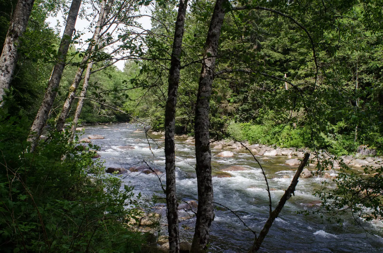
Photo: Jeff Hitchcock, Wikimedia Commons, CC BY 3.0
Seymour is in the District of North Vancouver. The District's street data marks all seven streets that had a home listed here on October 11, 2026 as District streets, and its boundary data returns the District for points on both banks of the river. That day, more than half of the listings left the municipality line blank, and the others were split evenly between "North Vancouver District" and "North Vancouver", so confirm it on the property tax notice.
What Seymour is like
The Seymour River runs through the middle of this area on its way to Burrard Inlet. Mount Seymour Parkway crosses it on a bridge, and Riverside Drive follows the east bank north until the houses end at the forest. Listings use the name Seymour for streets on both banks.
The area has three parts. West of the river, Seymour Boulevard and Heritage Boulevard form a pocket of homes between the water and Lillooet Park, the sports fields south of Capilano University. East of the river and north of the parkway, Riverside Drive and short streets such as Rivergrove Place climb beside the canyon. South of the parkway is Maplewood, where Seymour River Place runs past Maplewood Farm to the shops on Old Dollarton Road.
Most of the land is low and flat. Natural Resources Canada's elevation data gives 8 metres above sea level for Seymour River Place at Old Dollarton Road and 17 metres for Mount Seymour Parkway at Riverside Drive. The ground rises at the edges: Windridge Drive climbs from 18 metres at Riverside Drive to 52 metres at its east end, and the north end of Riverside Drive is at 61 metres.
The name Seymour has two meanings here. The District of North Vancouver uses it for the community that covers the largest area in the District, from the river east to Deep Cove, and it plans the streets south of the parkway as Maplewood Village Centre. This page covers the MLS® area only. In our view, it suits a buyer who wants trails within a short walk of home and accepts that most addresses here need a flood or wildfire check.
Live from the MLS® system
Homes for sale in Seymour
9 houses, townhouses and duplex homes are listed for sale in Seymour today, checked against the MLS® system within the last hour. Condos and apartments are not shown on this page.


Prices
What a home in Seymour costs
Two kinds of numbers, kept apart. The dots are asking prices of the homes listed in Seymour today, counted on this page. The cards are Greater Vancouver REALTORS benchmark prices for all of North Vancouver, which describe a typical home sold anywhere in North Vancouver.
Asking prices today
Each dot is one home for sale. The dark line marks the middle price.
Detached house
$2,042,000
- One year
- down 6.2%
- Ten years
- up 18.7%
North Vancouver benchmark, Greater Vancouver REALTORS, September 2026
Townhouse
$1,230,400
- One year
- down 4.9%
- Ten years
- up 43.2%
North Vancouver benchmark, Greater Vancouver REALTORS, September 2026
All home types
$1,290,400
- One year
- down 3.9%
- Ten years
- up 16.9%
North Vancouver benchmark, Greater Vancouver REALTORS, September 2026
What the homes are like
Only a small number of homes were for sale in Seymour on October 11, 2026, so the shares in this section can change with one new listing. Two thirds of the homes this page listed that day were detached houses and one third were townhouses. Condos were also for sale here, and this page leaves them out. The streets with homes listed were Seymour Boulevard, Heritage Boulevard, Tanager Place, Heritage Park Lane, Seymour River Place, Windridge Drive and Rivergrove Place.
The homes came from three decades in equal shares: the 1970s, the 1980s and the 2010s. The typical house was finished in the early 1980s and had four bedrooms and more than 2,400 square feet of floor space. The typical townhouse was finished in 2015 and had three bedrooms and more than 1,300 square feet.
Among the house listings that day, 17% stated a legal suite, 17% stated no suite and the others left the line blank. No house listing named an unauthorized suite. Across all the homes, 22% of listings said the home had a view and 22% said it had none.
Maplewood has the widest mix. The District's 2016 flood study described older rental townhouses, low-rise apartments, and old and new detached houses there. A townhouse is a strata home: you hold title to your own unit, the owners as a group hold the land and the outside of the buildings, and a monthly fee covers their upkeep. Before you make an offer, read the strata's meeting minutes, its budget and its depreciation report, a professional's long-term plan for repairs.
When the homes were built
Year built of the 9 listings that state it.
- 1970s3
- 1980s3
- 2010s3
Bedrooms
Bedrooms in the 9 listings that state it.
- 1 or 21
- 32
- 44
- 52
The homes listed today have been on the market for 24 days at the middle, counted from each listing date to today. That is how long they have waited so far, which is a different number from how long homes take to sell.
Seymour on the map
- Home for sale
- Public school
- Park
History
How Seymour began
The river gives the area its name. The province's place name record says the Seymour River honours Frederick Seymour, governor of the mainland colony of British Columbia from 1864 until his death in 1869. The Geographic Board of Canada adopted the name Seymour Creek on March 31, 1917, and the form changed to Seymour River on May 6, 1947. The record adds that the date the river first received the name is unknown.
The west bank near the river mouth is Squamish Nation reserve land, which a flood study written for the District in 2016 calls Seymour IR No. 2. On the east bank, the same study says building in lower Maplewood began in the 1920s with sawmills on the waterfront. The District's history of Maplewood Farm says the land was bought in 1914 and became a dairy farm in 1924, with a milk route that once served Deep Cove, Seymour and Lynnmour. The District bought the farm in 1970 and opened it to the public in June 1975.
People also changed the river. A dam has controlled its upper part since 1961. The 2016 study estimates that building in the late 1950s and early 1960s narrowed the channel between the parkway and Dollarton Highway by 40%. The largest flood on record came on October 31, 1981, when water carrying gravel and trees threatened bridges and properties in the Riverside area.
Architects designed houses on Riverside Drive in those years. The District's 1997 inventory of buildings from 1930 to 1965 lists a 1960 house at 1319 Riverside Drive by Blair MacDonald and Barry Downs, and a three-storey house that Ron Thom designed around 1963 on the most northerly Riverside Drive lot that faces the river.
Daily life
Daily life in Seymour
Maplewood Farm, at 405 Seymour River Place, is run by the District. Its park data describes a children's petting zoo and heritage farm that is open from 10 a.m. to 4 p.m. and charges an entry fee. The Ron Andrews Community Recreation Centre is up the hill at 931 Lytton Street. Its operator, North Vancouver Recreation and Culture, lists a 37.5 metre pool with six lanes, a squash court and a fitness studio.
For groceries, the map on this page shows a Real Canadian Superstore and Stong's Market as the nearest supermarkets, and several cafes. The nearest library branch on the map is Lynn Valley, which is a drive or a bus trip away.
Maplewood is changing. The District's page on Maplewood Village Centre says council approved a five-storey project in 2024 with 534 homes and space for new businesses, and that the project will add public squares, shops, walking paths and bike lanes. The District describes the village heart as the blocks between Old Dollarton Road and Dollarton Highway, west of Riverside Drive. Firefighters answered their first call from the new Maplewood Fire and Rescue Centre on January 15, 2025.
Grocery stores
- Real Canadian Superstore800 m
- Stong's Market910 m
Cafes
- Belmondo Cafe810 m
- Starbucks980 m
- Tim Hortons1.0 km
Libraries and rec centres
- The Hive880 m
- Ron Andrews Community Recreation Centre980 m
How far it is
- Downtown Vancouver (Waterfront Station)7.7 km
- Lonsdale Quay and the SeaBus5.1 km
- Lions Gate Hospital3.9 km
- Park Royal shopping centre9.1 km
Places from OpenStreetMap, read October 10, 2026. Distances are in a straight line from the middle of the area, so the trip by road is longer.
Outdoors
The river, the Spirit Trail and the forest reserve
Several small parks are inside the area. Hogan's Pools Park is at the corner of Mount Seymour Parkway and Riverside Drive, and Windridge Park is a forested park beside the recreation centre. The District's park data requires a leash for dogs in both. The District's page on Maplewood places Seymour River Heritage Park next to Maplewood Farm.
The Spirit Trail now crosses the area. The District finished the section from the Seymour River to Windridge Park on June 16, 2025. It starts where the older trail ended at Seymour Boulevard, runs on a new path through the greenbelt north of Kenneth Gordon Maplewood School to Riverside Drive, and then follows Windridge Drive, which was repaved with speed cushions and bike markings. On September 15, 2025, council moved the date for finishing the trail's eastern extension to 2029.
Two routes lead upriver. On the west side, Metro Vancouver's Seymour River Regional Greenway runs 1.7 kilometres from Mount Seymour Parkway at Lillooet Road past Capilano University to Monashee Drive, and continues into the Lower Seymour Conservation Reserve. On the east side, a staircase on the Baden-Powell Trail near the north end of Riverside Drive leads to the reserve's trails.
In December 2014, a rockslide in the canyon partly blocked the river, raised the water upstream, flooded trails and led Metro Vancouver to remove the Twin Bridge on Fisherman's Trail. It built the Seymour River Suspension Bridge in 2018 to restore the crossing. To the south, the District says the Maplewood conservation area on Burrard Inlet is managed by the Wild Bird Trust of BC.
Schools
Schools in and near Seymour
Seymour is in the North Vancouver School District. The three public elementary schools nearest the middle of the area are Seymour Heights on Carnation Street, Lynnmour on Forsman Avenue and Blueridge on Bronte Drive. The district's list of feeder schools places all three with Windsor Secondary on Broadview Drive, so each of them leads to the same high school.
Windsor Secondary also takes French immersion students. The district's list of French immersion feeder schools sends students on to Windsor from Dorothy Lynas and Sherwood Park, from late immersion at Boundary and from early and late immersion at Braemar. The province's school data shows no French immersion program at the three elementary schools near Seymour, so ask the district where a child from your address would start.
Kenneth Gordon, an independent school on Seymour River Place, is inside the area, and Lions Gate Christian Academy is on Tollcross Road. The table on this page gives the distance to each school. The river divides this area, so type each address into the district's school locator before you write an offer.
| School | Type | French programs | Distance |
|---|---|---|---|
Seymour Heights Elementary 2640 Carnation St, North Vancouver, BC | Public, elementary | None listed | 1.1 km |
Lynnmour Elementary School 800 Forsman Ave, North Vancouver, BC | Public, elementary | None listed | 1.2 km |
Blueridge Elementary 2650 Bronte Dr, North Vancouver, BC | Public, elementary | None listed | 1.5 km |
Eastview Elementary 1801 Mountain Hwy, North Vancouver, BC | Public, elementary | None listed | 2.2 km |
Windsor Secondary 931 Broadview Dr, North Vancouver, BC | Public, secondary | Early immersion | 1.2 km |
Sutherland Secondary 1860 Sutherland Ave, North Vancouver, BC | Public, secondary | None listed | 3.1 km |
Kenneth Gordon 420 Seymour River Pl, North Vancouver, BC | Independent, elementary-secondary | None listed | 550 m |
Lions Gate Christian Academy 919 Tollcross Rd, North Vancouver, BC | Independent, elementary-secondary | None listed | 1.4 km |
North Star Montessori Elementary School 1325 Keith Rd E, North Vancouver, BC | Independent, elementary | None listed | 1.7 km |
Brockton Preparatory School 3467 Duval Rd, North Vancouver, BC | Independent, elementary-secondary | None listed | 3.0 km |
Your address decides your assigned school, which can differ from the closest one. Check any address with the North Vancouver School District school locator. School list from the BC Ministry of Education, updated October 8, 2026.
Getting around
Getting around
Mount Seymour Parkway is the main road, with four lanes in the District's street data. It crosses the river and meets Lillooet Road beside the Highway 1 ramps for the Ironworkers Memorial Second Narrows Crossing. A second road bridge, on Grantham Place, joins Riverside Drive to Seymour Boulevard, so a driver can change banks without using the parkway. In our experience, traffic for the Second Narrows decides how long a drive to Vancouver or Burnaby takes in the late afternoon.
Five bus routes stop in or beside the area, and the table on this page counts the weekday trips on each. The 211 runs along the parkway. TransLink's schedule for September 7, 2026 to January 3, 2027 gives 32 to 39 minutes from the stop at Seymour Boulevard to Burrard Station for weekday buses that leave between 7 and 9 a.m., and 40 to 45 minutes back for buses that leave Burrard Station between 4 and 6 p.m. The last weekday 211 that continues downtown passes Seymour Boulevard at 6:06 p.m., and later buses end at Phibbs Exchange, 4 to 7 minutes away.
The 214 and 215 serve Maplewood from Old Dollarton Road at Riverside Drive, and the schedule gives them 2 to 6 minutes to Phibbs Exchange. Five morning 214 buses continue to Burrard Station in 34 to 36 minutes. West of the river, the 245 and 255 stop on Lillooet Road at the parkway, and the 245 takes 4 to 6 minutes to Phibbs Exchange. People who cycle can follow the Spirit Trail west from Seymour Boulevard.
Routes that stop in Seymour
Trips on a regular weekday that stop at one of the 16 stops inside the area, from TransLink's published schedule valid to January 3, 2027.
- 245Phibbs Exchange/Capilano University284 trips
- 255Dundarave/Capilano University100 trips
- 211Seymour/Phibbs Exchange/Burrard Station89 trips
- 215Indian River/Phibbs Exchange88 trips
- 214Blueridge/Phibbs Exchange/Burrard Station75 trips
Before you buy
Things to check in Seymour
River flooding
The District's Creek Hazard area covers properties beside a watercourse that may flood. On October 11, 2026, its map data showed areas labelled as a potential flood hazard within 40 metres of six of the seven streets that had homes listed that day. Rivergrove Place was the exception. The District's 2016 study reports a model of a river flood with a 0.5% chance in any year, with water 0.1 to 0.5 metres deep in Maplewood Village. An existing lawful house may remain unchanged. New living space, such as a finished basement, needs a permit and an engineer's flood report.
Forest edge
Wildfire Hazard areas lay within 40 metres of six of the seven streets on the same date, and Seymour River Place was the exception. The District's data labels most of them Wildfire Interface Area and a few Wildfire Risk Area. Ask an insurer for a quote on the address before your offer becomes firm.
Slopes at the edges
Slope Hazard areas lay within 40 metres of Seymour Boulevard, Heritage Boulevard, Windridge Drive and Rivergrove Place. Windridge Drive climbs 34 metres between Riverside Drive and its east end. Search the address on GeoWeb, the District's online property map, and ask the seller for any engineer's report on the lot.
Reserve land and title
Squamish Nation reserve land lies beside the south end of Seymour Boulevard. The District's map data shows it within 25 metres of that street from the 300 block to the 600 block, and beside no part of the street from number 661 north. We found no public source that lists homes for sale to the public on the reserve. Each listing states freehold title, where you own the land, or leasehold title, where you buy the use of the home for a fixed number of years. Have your lawyer or notary confirm it in the title search.
Building in Maplewood
The District names Maplewood Village Centre as one of its growth areas. Besides the 534 homes approved in 2024, a six-storey building with 81 homes for Metro Vancouver Housing, near Old Dollarton Road and Riverside Drive, went to council for its permit on July 13, 2026. For a home south of the parkway, ask the District which approved sites are close to the address.
Winter roads
The District clears snow by three priority levels. Its map data puts the four-lane roadway of Mount Seymour Parkway in the first level, and Seymour Boulevard, Heritage Boulevard, Tanager Place, Heritage Park Lane, Windridge Drive and Rivergrove Place in the third. Riverside Drive has stretches in all three, so ask a neighbour how soon the plough reaches your block.
Buying
Buying a home in Seymour
Start with the map. The river splits the area, and the two banks differ in the nearest bus stop, the nearest bridge and the trip to school. Then decide between a detached house and a townhouse. On October 11, 2026, the typical house listed here was more than 30 years older than the typical townhouse. The price dots on this page show today's asking prices for each type.
Before you write an offer, search the address on GeoWeb for the flood, wildfire and slope areas described on this page, and ask the seller for any report they hold. Ask an insurer what flood cover costs for that address. For a townhouse, read the strata papers with your lawyer or notary.
Gary Paul works with buyers across North Vancouver. Send the form on this page with your budget, the bedrooms you need and which side of the river you prefer, and he will reply with the Seymour homes that match and book the showings.
Selling
Selling a home in Seymour
Few homes are for sale in Seymour at one time, so a buyer who comes to see yours has usually seen the others on this page. In our experience, the same buyer is also touring Blueridge, Windsor Park or the newer townhouses in Lynnmour. The cards on this page show today's count of homes and the range of their asking prices.
In our experience, three things set the price of a home here: which hazard areas cover the lot and what reports the owner can show, the condition of the house or the strata's savings, and how close the home is to the parkway or to a building site in Maplewood. Before you list, print the GeoWeb map for your address and collect any flood or slope report, because careful buyers search the address themselves.
Real estate board rules keep sold prices off public pages such as this one. Gary Paul can show you recent Seymour sales in a private price review and recommend a list price. Use the form on this page to ask for one.
Houses listed
6
$1.59M to $3.75M
Townhouses listed
3
$1,000K to $1.42M
Our view
Who buys in Seymour
In our experience, the most common buyer is a family that walks, runs or rides in the forest every week and wants a trail within a short walk of home. Many of them move from a condo in Vancouver or Lower Lonsdale and want three or four bedrooms.
A second group, in our experience, works across the Second Narrows in Burnaby or East Vancouver and wants Phibbs Exchange and the highway ramps a few minutes away. A third group works or studies at Capilano University, which is next to the homes west of the river.
Seymour and the areas next to it
Homes listed for sale today, counted on this page.
| Area | For sale | Middle asking price | Houses, middle price |
|---|---|---|---|
| Seymour | 9 | $1.80M | $2.08M |
| Lynnmour | 21 | $1.27M | $2.00M |
| Windsor Park | 5 | $1.47M | $2.10M |
| Blueridge | 9 | $2.35M | $2.35M |
Questions about Seymour
Is Seymour in the City or the District of North Vancouver?
Seymour is in the District of North Vancouver. District street data marks each street that had a home listed here on October 11, 2026 as a District street. Many listings leave the municipality line blank or say only "North Vancouver", so check the property tax notice.
Where is the Seymour MLS® area, and is it the same as the District's Seymour community?
The MLS® area is a small one on both banks of the lower Seymour River, around Mount Seymour Parkway, Riverside Drive and Maplewood. The District of North Vancouver uses the name Seymour for a larger community that runs from the river east to Deep Cove. This page covers the MLS® area.
What kind of homes are for sale in Seymour?
On October 11, 2026, two thirds of the homes this page listed in Seymour were detached houses and one third were townhouses. They were built in the 1970s, the 1980s and the 2010s in equal shares. Condos were also for sale, and this page leaves them out.
How much does a house in Seymour cost?
The price dots on this page mark the asking price of each house listed in Seymour today and show the middle price. The page also gives the monthly benchmark price that Greater Vancouver REALTORS publishes for a detached house across North Vancouver.
Is Seymour at risk of flooding from the Seymour River?
Parts of it are. On October 11, 2026, District map data showed potential flood hazard areas within 40 metres of six of the seven streets that had homes listed. Search each address on GeoWeb, the District's property map, and ask an insurer about flood cover.
Are any homes in Seymour on leasehold land?
Squamish Nation reserve land lies beside the south end of Seymour Boulevard, and we found no public source that lists homes for sale to the public on it. Every listing states freehold or leasehold title. Read that line and ask your lawyer or notary to confirm it.
Which schools serve Seymour?
The nearest public elementary schools are Seymour Heights, Lynnmour and Blueridge, and the North Vancouver School District groups all three with Windsor Secondary. Kenneth Gordon, an independent school, is on Seymour River Place. Check each address in the district's school locator, because the river divides the area.
How long is the bus ride from Seymour to downtown Vancouver?
TransLink's schedule for September 7, 2026 to January 3, 2027 gives the 211 bus 32 to 39 minutes from Mount Seymour Parkway at Seymour Boulevard to Burrard Station on weekdays between 7 and 9 a.m. The trip back between 4 and 6 p.m. is given 40 to 45 minutes.
Is Seymour good for families?
In our view, yes for a family that likes the outdoors. Maplewood Farm, the Spirit Trail, river parks and a recreation centre with a pool are close, and three elementary schools lead to one high school. The trade-offs are flood and wildfire checks, bridge traffic and building work in Maplewood.
What happened in the 2014 Seymour River rockslide?
In December 2014, a rockslide in the Seymour River canyon partly blocked the river, raised the water upstream and flooded trails, and Metro Vancouver removed the Twin Bridge on Fisherman's Trail. It built the Seymour River Suspension Bridge in 2018 to restore the crossing.
Where does the name Seymour come from?
The province's place name record says the Seymour River honours Frederick Seymour, governor of the mainland colony of British Columbia from 1864 to 1869. The name Seymour Creek was adopted on March 31, 1917 and changed to Seymour River on May 6, 1947.
How do I find out what my Seymour home is worth?
Ask for a price review with the form on this page. Gary Paul will compare your home with recent Seymour sales and with the homes for sale now, and tell you in private what list price he would suggest.
Who should I talk to about buying or selling in Seymour?
Gary Paul, REALTOR®, Personal Real Estate Corporation, with Grand Central Realty, works with buyers and sellers across North Vancouver for MultiLiving. Send the form on this page or phone him at 778-828-7476.
Sources
Written content checked October 11, 2026. Listing numbers counted from the MLS® system on October 12, 2026.
- Seymour (the community and its neighbourhoods; page last edited October 2, 2026), District of North Vancouver. Read October 11, 2026.
- Maplewood Village Centre and area (page last edited July 22, 2025), District of North Vancouver. Read October 11, 2026.
- Seymour River (name record 15310), BC Geographical Names Office, Government of British Columbia. Read October 11, 2026.
- Maplewood Village Flood Risk Management Strategy, final report (Northwest Hydraulic Consultants, September 22, 2016), District of North Vancouver. Read October 11, 2026.
- Maplewood Farm turns 50, District of North Vancouver. Read October 11, 2026.
- District of North Vancouver Heritage Inventory Update 1930 to 1965 (1997), 1319 and 2357 Riverside Drive, District of North Vancouver. Read October 11, 2026.
- Public map service (streets, boundary, creeks, reserve land, parks, dogs in parks, snow routes and hazard areas), District of North Vancouver. Read October 11, 2026.
- GeoWeb property viewer (hazard areas by address), District of North Vancouver. Read October 11, 2026.
- Creek Hazard Development Permit Area: frequently asked questions (2024), District of North Vancouver. Read October 11, 2026.
- Elevation service, Canadian Digital Elevation Model (heights at street corners), Natural Resources Canada. Read October 11, 2026.
- Spirit Trail Eastern Extension, District of North Vancouver. Read October 11, 2026.
- Riverside Drive affordable housing site, District of North Vancouver. Read October 11, 2026.
- Seymour River Canyon Trail Connections Project (fact sheet, June 2018), Metro Vancouver. Read October 11, 2026.
- Lower Seymour Conservation Reserve Management Plan 2022, Metro Vancouver. Read October 11, 2026.
- Seymour River Regional Greenway, Metro Vancouver. Read October 11, 2026.
- Ron Andrews Community Recreation Centre, North Vancouver Recreation and Culture Commission. Read October 11, 2026.
- Families of Schools (feeder schools and French immersion feeder schools), North Vancouver School District. Read October 11, 2026.
- TransLink schedule data (GTFS), in effect September 7, 2026 to January 3, 2027, TransLink. Read October 11, 2026.
- MLS® Home Price Index, September 2026 stats package, Greater Vancouver REALTORS. Read October 9, 2026.
- K-12 school locations (school names, addresses and programs), BC Ministry of Education and Child Care, through the BC Data Catalogue. Read October 9, 2026.
- Places, parks and shops, OpenStreetMap contributors (Open Database License). Read October 9, 2026.
- Bus, SeaBus and train schedules (GTFS feed 26SEP_20261009), TransLink. Read October 9, 2026.
General information only. The prices, benchmarks, strata rules, tax and fee figures, lease terms, permit rules and school details on this page are based on the sources and dates listed above. They are not financial, mortgage, tax or legal advice, and not a guarantee of any outcome. Prices, tax rates, fees, municipal rules and school catchments change. Before you buy or sell, confirm each one with its source and speak with a licensed REALTOR®, a mortgage broker and a real estate lawyer.