West Vancouver neighbourhood guide
Sandy Cove, West Vancouver: Homes for Sale, Prices, Schools and Daily Life
Sandy Cove is a small waterfront neighbourhood of detached houses in West Vancouver, on Marine Drive between West Bay and Cypress Park. Houses stand along Marine Drive and on Rose Crescent above it, and Sandy Cove Park has a sand beach at the east end. It suits a buyer who wants a house beside the water or looking over it, and who will drive or ride the bus for shopping.
For sale now
4
houses, townhouses, duplexes
Asking prices
$2.99M to $8.95M
Middle asking price
$4.87M
West Vancouver detached benchmark
$2.82M
September 2026, GVR
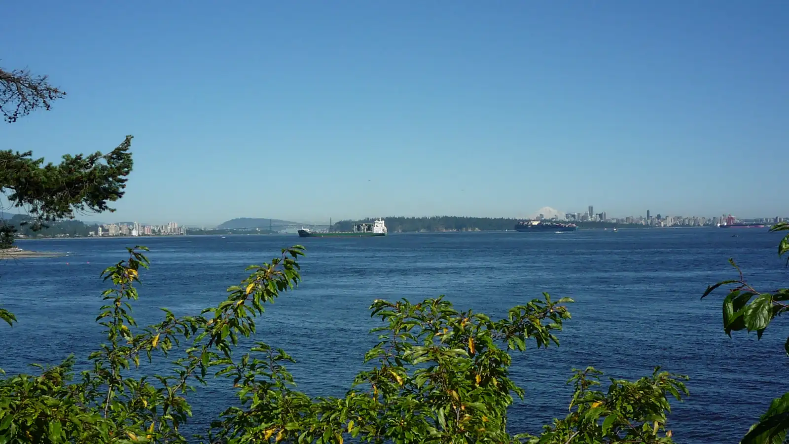
Photo: Colin W, Wikimedia Commons, CC BY-SA 3.0
Sandy Cove is in the District of West Vancouver. The province's place name office records the community of Sandy Cove as part of the District, and its name search gives November 26, 1979 as the date the name was adopted. On October 11, 2026, every listing here left the municipality line blank, so confirm the municipality on the property tax notice for each home.
What Sandy Cove is like
Sandy Cove is the name of a cove and of the small neighbourhood behind it. The West Vancouver Archives describes the neighbourhood as the land from the corner of Sharon Drive and Marine Drive west to a point just past the federal fisheries research centre, between the waterfront and the railway line. On OpenStreetMap that part of Marine Drive is 857 metres long. Bayridge is on the hill above the tracks, and Cypress Park is to the west.
Three streets hold most of the houses. Marine Drive follows the shore. East of the research centre, OpenStreetMap puts the road between 72 and 91 metres from the shoreline, and the lots on its south side reach the sea. Rose Crescent leaves Marine Drive beside Sandy Cove Park, runs for 829 metres along the slope above and ends at Burkehill Road. Sherman Street, 99 metres long, joins the two. The ground rises from the beach to the railway, which the map places between 121 and 217 metres north of Marine Drive.
In our view, Sandy Cove suits a buyer who wants the sea at the edge of the lot or in view from the slope, and who accepts a main road and a railway close to home. We think a buyer who wants shops within walking distance will be happier in Dundarave or near Caulfeild Village.
Live from the MLS® system
Homes for sale in Sandy Cove
4 houses, townhouses and duplex homes are listed for sale in Sandy Cove today, checked against the MLS® system within the last hour. Condos and apartments are not shown on this page.


Prices
What a home in Sandy Cove costs
Two kinds of numbers, kept apart. The dots are asking prices of the homes listed in Sandy Cove today, counted on this page. The cards are Greater Vancouver REALTORS benchmark prices for all of West Vancouver, which describe a typical home sold anywhere in West Vancouver.
Asking prices today
Each dot is one home for sale. The dark line marks the middle price.
Detached house
$2,822,900
- One year
- down 9.9%
- Ten years
- down 21.9%
West Vancouver benchmark, Greater Vancouver REALTORS, September 2026
All home types
$2,244,700
- One year
- down 7.4%
- Ten years
- down 26.7%
West Vancouver benchmark, Greater Vancouver REALTORS, September 2026
Greater Vancouver REALTORS published no West Vancouver townhouse benchmark in its September 2026 report, so none is shown.
What the homes are like
Sandy Cove is a small waterfront area, and few homes are for sale here at one time. On October 11, 2026, every home this page listed in Sandy Cove was a detached house, on Marine Drive or Rose Crescent. No townhouse, duplex home or condo was listed that day. The West Bay and Caulfeild pages show more homes on the same shore.
The houses listed that day came from two periods. Half had been finished before 1960, and the other half dated from the 1990s and the 2010s in equal shares. The middle house had four bedrooms and more than 3,600 square feet of floor space, on a lot larger than 13,000 square feet.
Every listing description that day mentioned a view. Half of the listings stated a suite and called it unauthorized, which means the District has not approved it. A quarter said the house had no suite, and a quarter left the line blank.
When the homes were built
Year built of the 4 listings that state it.
- Before 19602
- 1990s1
- 2010s1
Bedrooms
Bedrooms in the 4 listings that state it.
- 31
- 43
Suites: of the 3 houses for sale whose listing states it, 0 list a legal or licensed suite, 2 list a suite the municipality has not approved, and 1 list none. The rest leave the field blank.
The homes listed today have been on the market for 45 days at the middle, counted from each listing date to today. That is how long they have waited so far, which is a different number from how long homes take to sell.
Sandy Cove on the map
- Home for sale
- Public school
- Park
History
How Sandy Cove got its name
The West Vancouver Archives records that the Squamish People named this place Stḵ'iil, and says the name possibly refers to the smell of the mud at low tide. Fisheries and Oceans Canada, which runs the research centre on the shore, says the site held a First Nations village before Europeans arrived and that its waters were valued for rockfish and salmon.
Settlers first called the area Sherman. The archives says the name came from Alfred H. Sherman and Rose Sherman, early residents who owned property here. It adds that Sherman was also the name of a stop on the Pacific Great Eastern Railway, north of the top of Sherman Street. People stopped using the name over time. The province's place name office still holds a record for Sherman as a post office name and marks it as not official. Its name search gives November 26, 1979 as the date of the decision on both names: Sherman was rescinded and Sandy Cove was adopted for the community.
The cove kept its name after an official tried to change it. In 1929, H.D. Parizeau of the Department of Marine and Fisheries recommended the name Ettershank Cove, after Captain William Ettershank, the senior Vancouver pilot from 1877 to 1920. Local people kept using the name Sandy Cove, and it was restored, the archives says. The province's name search gives March 3, 1949 as the date Sandy Cove was adopted for the water.
A fish cannery operated on this shore for more than 60 years. Fisheries and Oceans Canada says the Defiance Cannery was at Sandy Cove from the late 1800s and was renamed the Great Northern Cannery in 1927, and that generations of workers lived on the site with their families. By the mid-1960s the Millerd family, which then owned the cannery, agreed to sell it to the Government of Canada on condition that it be used for research. The Pacific Environment Institute opened there in 1970. It was later renamed the West Vancouver Laboratory and is now the Pacific Science Enterprise Centre, at 4160 Marine Drive.
Daily life
Daily life in Sandy Cove
The map data on this page shows no grocery store, cafe, pharmacy or clinic inside the area. The nearest supermarket in the tables is a Safeway, which OpenStreetMap places inside the Caulfeild Village shopping centre on Headland Drive, with a pharmacy and a medical clinic beside it. For a street of shops and cafes, TransLink's schedule gives the 250 bus five to six minutes from Sherman Street to 25th Street in Dundarave.
The Pacific Science Enterprise Centre occupies the west end of the shore. OpenStreetMap draws its grounds at more than three hectares, with a pier. Fisheries and Oceans Canada's page, last changed on May 22, 2018, lists indoor and outdoor tanks supplied with fresh and salt water, docks, laboratories and offices. The public beach is at the other end of the neighbourhood, in Sandy Cove Park.
Marine Drive is the main road. OpenStreetMap marks it as two lanes that bicycles share with cars, and marks the part from Sandy Cove Park east toward West Bay as having no sidewalk. In our experience, the road is slow behind a bus or a group of cyclists, because there is one lane each way.
Grocery stores
Nearest: Safeway, 1.9 km away.
Cafes
Nearest: Delany's Coffee House, 3.8 km away.
Libraries and rec centres
Nearest: Gleneagles Community Centre, 4.2 km away.
How far it is
- Downtown Vancouver (Waterfront Station)10.6 km
- Lonsdale Quay and the SeaBus11.2 km
- Lions Gate Hospital12.0 km
- Park Royal shopping centre6.9 km
Places from OpenStreetMap, read October 10, 2026. Distances are in a straight line from the middle of the area, so the trip by road is longer.
Outdoors
Sandy Cove Park, the beach and the shore
Sandy Cove Park is a small District park between Marine Drive and the sea, at the east end of the neighbourhood. OpenStreetMap shows steps down from a marked crossing on Marine Drive, a footbridge 45 metres long, a public washroom and a sand beach 119 metres wide. It marks the beach as having no lifeguard and shows free roadside parking beside the park. Check the signs there for hours and for rules on dogs.
Look at the water reports before you swim. On August 2, 2018, the District announced that Vancouver Coastal Health had lifted a water quality advisory, and that swimming and wading were safe again at Sandy Cove, Ambleside Park and Whytecliff Park. The health authority publishes beach water reports, so read the latest one in summer.
The tables on this page list McKechnie Park, east of Sharon Drive, and Erwin Park, a small shore park to the west. The photo at the top of this page was taken at Caulfeild Park, 1.5 kilometres west of the centre of Sandy Cove. It looks east over the water that Sandy Cove also faces, toward the Lions Gate Bridge, Stanley Park and downtown Vancouver.
Schools
Schools near Sandy Cove
Sandy Cove is in West Vancouver Schools (School District 45). The nearest public school is Cypress Park Primary, at 4355 Marine Drive in the next neighbourhood to the west. The district says it teaches Kindergarten to Grade 3 in single-grade groups and follows the International Baccalaureate Primary Years Programme, and that all of its students may move on to West Bay Elementary for the later grades.
West Bay Elementary, on Thompson Place, teaches Kindergarten to Grade 7 in the same programme. Caulfeild Elementary on Keith Road, which also teaches Kindergarten to Grade 7, is closer to Sandy Cove in the table on this page. The province's school data shows no French immersion program at Cypress Park, Caulfeild or West Bay.
For Grades 8 to 12, the nearest public school in the table is Rockridge Secondary on Headland Drive, across from the Caulfeild Village shops. The district says Rockridge offers Advanced Placement courses in Grades 11 and 12.
The school a child may attend depends on the home address. On October 12, 2026, the district's website said admissions would open on October 15, 2026 for all Kindergarten students and for students in Grades 1 to 12 who live inside a school's boundary. Enter the address of any house you consider in the district's school locator. Mulgrave School and Collingwood School are the nearest independent schools in the table.
| School | Type | French programs | Distance |
|---|---|---|---|
Cypress Park Primary 4355 Marine Dr, West Vancouver, BC | Public, elementary | None listed | 540 m |
Caulfeild Elementary 4685 Keith Rd, West Vancouver, BC | Public, elementary | None listed | 1.5 km |
West Bay Elementary 3175 Thompson Pl, West Vancouver, BC | Public, elementary | None listed | 2.0 km |
Eagle Harbour Montessori 5575 Marine Dr, West Vancouver, BC | Public, elementary | None listed | 2.5 km |
Rockridge Secondary 5350 Headland Dr, West Vancouver, BC | Public, secondary | None listed | 1.8 km |
West Vancouver Secondary 1750 Mathers Ave, West Vancouver, BC | Public, secondary | None listed | 5.0 km |
Mulgrave School 2330 Cypress Bowl Lane, West Vancouver, BC | Independent, elementary-secondary | None listed | 2.8 km |
Collingwood School 70 Morven Dr, West Vancouver, BC | Independent, elementary-secondary | None listed | 3.4 km |
St. Anthony's 595 Keith Rd, West Vancouver, BC | Independent, elementary | None listed | 7.2 km |
Bodwell High School 955 Harbourside Drive, North Vancouver, BC | Independent, secondary | None listed | 9.9 km |
Your address decides your assigned school, which can differ from the closest one. Check any address with the West Vancouver Schools school locator. School list from the BC Ministry of Education, updated October 8, 2026.
Getting around
Getting around
Buses stop on Marine Drive at Sharon Drive, Rose Crescent and Sherman Street. The 250 runs between Horseshoe Bay and downtown Vancouver. For weekday buses that leave Sherman Street between 7 and 9 a.m., TransLink's schedule for September 7, 2026 to January 3, 2027 allows between 32 and 37 minutes to West Georgia Street at Burrard Street. The first weekday 250 toward Vancouver passes Sherman Street at 6:22 a.m. and the last at 12:27 a.m.
Coming home, the eight buses that leave West Georgia Street at Richards Street between 4:05 and 5:50 p.m. are each given 39.8 minutes to Sherman Street. Going west, the schedule gives the 250 between 14 and 22 minutes from Sherman Street to the Horseshoe Bay ferry terminal.
The 253 stops here in one direction only. Toward Park Royal it runs along Marine Drive and passes Sherman Street 25 times on a weekday, from 6:42 a.m. to 10:54 p.m., and nine of those trips continue to downtown Vancouver. Toward Caulfeild it follows streets higher on the hill, so a rider coming home to Sandy Cove takes the 250.
Drivers use Marine Drive in both directions: east to Dundarave, Ambleside and the Lions Gate Bridge, and west to Caulfeild and Horseshoe Bay. Two roads climb from Marine Drive to Bayridge: Sharon Drive and Burkehill Road. OpenStreetMap shows each one crossing the railway at a level crossing, where the road and the track meet at the same height.
Routes that stop in Sandy Cove
Trips on a regular weekday that stop at one of the 11 stops inside the area, from TransLink's published schedule valid to January 3, 2027.
- 250Horseshoe Bay/Dundarave/Vancouver95 trips
- 253Caulfeild/Vancouver/Park Royal48 trips
Before you buy
Things to check in Sandy Cove
A lot on the shore
The District's community plan has a permit area for land the sea may flood. Unless an engineer works out a figure for the lot, the plan sets the lowest floor height for new living space between Sharon Drive and Ferndale Avenue, which includes the Sandy Cove shore, at 6.87 metres in Canada's national height system. A new house should also stand at least 15 metres back from where the high water mark is expected to be in the year 2100. Within 15 metres of today's high water mark, a pool, a hot tub, a shed or a retaining wall needs a permit. Ask the District whether a lot is inside the area.
Stairs and walls at the water
The community plan calls the strip between the high and low water marks the foreshore, and treats it as public. It says new structures should stand on private land above the high water mark where possible. Work on the public foreshore, including work on a structure that already reaches onto it, must meet the District's zoning rules and the conditions of a lease with the Province. The plan supports a seawall or a rock wall only where an engineer finds that softer, natural materials are not suitable for the site. If a house has private stairs or a wall at the water, ask the seller for the permits and ask the District what its records show.
Trees near the water
West Vancouver's Tree Bylaw protects every tree on land within 15 metres of the high water mark, whatever its size. Inside a shoreline zone that the Province has mapped, it also protects six named kinds of tree with a trunk wider than 20 centimetres, among them arbutus, shore pine and Pacific dogwood. A tree that holds the nest of an eagle or a heron is protected too. Cutting a protected tree needs a permit. Before you plan to cut or trim trees for a view, ask the District which trees on the lot are protected.
The road and the railway
A main road and a railway cross Sandy Cove from end to end. Transport Canada's inventory of crossings, built from data as of December 5, 2022, lists five trains a day at the public crossings at Sharon Drive and Burkehill Road, with a top train speed of 20 miles per hour, which is 32 kilometres per hour. OpenStreetMap shows the tracks within 19 metres of Rose Crescent. Visit a house at several times of day and listen from the bedrooms and the garden.
Godman Creek
The province's place name office records that Godman Creek flows southwest into Sandy Cove, and OpenStreetMap shows it in pipes beside Rose Crescent and Marine Drive, west of the park. The community plan protects land beside creeks in existing neighbourhoods. Within 15 metres of the top of a creek bank, a new building or paved surface should be at least as far from the creek as what stands there now, and the 5 metres nearest the bank should stay free of both. Ask the seller whether the creek or a creek pipe crosses the lot.
The wildfire map
The community plan's wildfire permit area is drawn on a District map, so each address has to be looked up. Inside it, a new house needs a permit. The guidelines ask for at least 10 metres between a new building and the edge of the forest, a roof of fire-rated material such as asphalt or metal, and conifer branches pruned to a height of 2.5 metres in the cleared space around the house. Phone a home insurer with the address before your offer becomes final.
Buying
Buying a home in Sandy Cove
Start by choosing a side of Marine Drive. A house on the south side has the sea at the edge of the lot, and the shore checks on this page apply to it. A house on the north side or on Rose Crescent looks over the road and the roofs below, and stands nearer the tracks. Go to the upper windows of each house and see what stands between you and the water.
Then look at the age of the house. On October 11, 2026, half of the houses listed here dated from before 1960. Make an offer on an older house depend on a full inspection, and ask about the roof, the wiring, the drains and any buried oil tank. For a house with a suite that the listing calls unauthorized, ask a mortgage broker whether the lender will count the rent.
Michael Lee works with buyers in Sandy Cove and across West Vancouver. Send the form on this page with your budget, the bedrooms you need and whether the house must be on the water, and he will reply with the homes that match. The price dots on this page show today's asking prices.
Selling
Selling a home in Sandy Cove
In our experience, a buyer for a Sandy Cove house has chosen the West Vancouver shore first and the street second. The same buyer often tours West Bay, Cypress Park and the lower streets of Caulfeild in the same weeks. The cards on this page show the homes listed in Sandy Cove today and the range of their asking prices.
In our experience, buyers here ask about four things: the view, the way from the house to the water, the sound of the road and the trains, and the age of the house. Prepare the papers before you list: a survey of the lot, the District's record of permits for the house and for any stairs or walls at the shore, and any engineer's report on flooding or on the slope.
Real estate board rules keep sold prices off public pages such as this one. In a private price review, Michael Lee can show you recent sales in Sandy Cove and on the shore nearby, and suggest a list price. Ask for one with the form on this page.
Houses listed
4
$2.99M to $8.95M
Our view
Who buys in Sandy Cove
In our experience, the most common buyer in Sandy Cove already lives on the North Shore or on Vancouver's west side and has decided to live beside the water. Many are couples whose children have grown up. Some are families who like having a primary school a short way along Marine Drive.
A second group, in our experience, buys an older house on a large lot for the land and the view, and plans to change the house over time.
Sandy Cove and the areas next to it
Homes listed for sale today, counted on this page.
Questions about Sandy Cove
Is Sandy Cove part of West Vancouver?
Yes. Sandy Cove is a neighbourhood in the District of West Vancouver. The West Vancouver Archives describes it as the land from Sharon Drive west to just past the federal fisheries research centre, between the waterfront and the railway line.
What kind of homes are for sale in Sandy Cove?
On October 11, 2026, every home this page listed in Sandy Cove was a detached house, on Marine Drive or Rose Crescent. Half dated from before 1960. The middle house had four bedrooms and more than 3,600 square feet of floor space.
How much does a house in Sandy Cove cost?
The price dots on this page mark the asking price of each Sandy Cove house for sale today. The page also gives the detached house benchmark for West Vancouver that Greater Vancouver REALTORS publishes each month, so you can compare the two.
How did Sandy Cove get its name?
Local people have long called the cove Sandy Cove. In 1929 a federal official recommended Ettershank Cove, after a Vancouver pilot, but residents kept using the old name and it was restored, the West Vancouver Archives says. The area itself was once called Sherman.
What was the Great Northern Cannery?
It was a fish cannery on the Sandy Cove shore. Fisheries and Oceans Canada says it began as the Defiance Cannery in the late 1800s, took the name Great Northern in 1927, and that its owners agreed in the mid-1960s to sell it to the Government of Canada for research. A federal research centre has used the site since 1970.
Is there a public beach at Sandy Cove?
Yes. Sandy Cove Park, a District park at the east end of the neighbourhood, has a sand beach that OpenStreetMap draws 119 metres wide, with steps down from Marine Drive and a public washroom. The map marks the beach as having no lifeguard.
Which schools serve Sandy Cove?
Sandy Cove is in West Vancouver Schools (School District 45). Cypress Park Primary on Marine Drive is the nearest public school and teaches Kindergarten to Grade 3. The table on this page also lists Caulfeild Elementary, West Bay Elementary and Rockridge Secondary. Enter each address in the district's school locator to confirm.
How long is the bus ride from Sandy Cove to downtown Vancouver?
TransLink's fall 2026 schedule gives the 250 bus between 32 and 37 minutes from Marine Drive at Sherman Street to West Georgia Street at Burrard Street, for weekday buses that leave between 7 and 9 a.m. Buses home between 4:05 and 5:50 p.m. are given 39.8 minutes.
What should I check before buying a waterfront house in Sandy Cove?
Ask the District whether the lot is in the permit area for land the sea may flood. Between Sharon Drive and Ferndale Avenue, the community plan sets the lowest floor height for new living space at 6.87 metres. Ask the seller for the permits for any stairs or walls at the water.
Do trains run past Sandy Cove?
Yes. A railway runs along the top of the neighbourhood, above Rose Crescent. Transport Canada's inventory of crossings, built from data as of December 5, 2022, lists five trains a day at the Sharon Drive and Burkehill Road crossings, at up to 20 miles per hour.
Is Sandy Cove good for families?
In our view, it suits a family that wants a beach close to home and does not mind driving. A primary school is a short way west on Marine Drive. The drawbacks are the main road, the trains, the lack of shops and the small number of homes for sale.
How do I find out what my Sandy Cove home is worth?
Ask for a price review with the form on this page. Michael Lee will compare your view, your lot, your access to the water and the age of your house with recent sales nearby, and he will share sold prices with you in private.
Who should I talk to about buying or selling in Sandy Cove?
Michael Lee, REALTOR®, Personal Real Estate Corporation, with eXp Realty, is the MultiLiving agent for West Vancouver. Phone him at 604-803-9863 or send the form on this page, and say whether you plan to buy, to sell or both.
Sources
Written content checked October 12, 2026. Listing numbers counted from the MLS® system on October 12, 2026.
- Sandy Cove (community): location in the District of West Vancouver, BC Geographical Names, Government of British Columbia. Read October 12, 2026.
- Sandy Cove (cove): official name and location, BC Geographical Names, Government of British Columbia. Read October 12, 2026.
- Sherman (post office name, not official), BC Geographical Names, Government of British Columbia. Read October 12, 2026.
- Godman Creek: official name and location (flows southwest into Sandy Cove), BC Geographical Names, Government of British Columbia. Read October 12, 2026.
- Sandy Cove (West Vancouver, B.C.): place record with boundaries and origin note (read in an archived search results page, copy of May 5, 2024), West Vancouver Archives. Read October 12, 2026.
- Pacific Science Enterprise Centre: Our history (page last modified May 22, 2018), Fisheries and Oceans Canada. Read October 12, 2026.
- Pacific Science Enterprise Centre: facilities and address (page last modified May 22, 2018), Fisheries and Oceans Canada. Read October 12, 2026.
- Beaches now open at Ambleside, Whytecliff and Sandy Cove, August 2, 2018 (archived copy of October 11, 2018), District of West Vancouver. Read October 12, 2026.
- Official Community Plan, Schedule ii: Area-Specific Policies and Guidelines (wildfire NE 1, shore NE 2, creeks NE 13; file last modified February 4, 2025), District of West Vancouver. Read October 12, 2026.
- Tree Bylaw No. 4892, 2016, consolidated to Amendment Bylaw No. 5373, 2025, District of West Vancouver. Read October 12, 2026.
- Grade Crossings Inventory, 2023 update (data as of December 5, 2022): Sharon Drive and Burkehill Road crossings, Transport Canada, through the Government of Canada open data portal. Read October 12, 2026.
- TransLink schedule data (GTFS), in effect September 7, 2026 to January 3, 2027, TransLink. Read October 12, 2026.
- Cypress Park (IB PYP), West Vancouver Schools. Read October 12, 2026.
- Rockridge (location, grades and programs), West Vancouver Schools. Read October 12, 2026.
- Primary and elementary schools (school list, school locator and admissions notice), West Vancouver Schools. Read October 12, 2026.
- Map data for Sandy Cove: streets, railway, park, beach, creek and the Caulfeild Village shops, OpenStreetMap contributors (Open Database License). Read October 12, 2026.
- MLS® Home Price Index, September 2026 stats package, Greater Vancouver REALTORS. Read October 9, 2026.
- K-12 school locations (school names, addresses and programs), BC Ministry of Education and Child Care, through the BC Data Catalogue. Read October 9, 2026.
- Places, parks and shops, OpenStreetMap contributors (Open Database License). Read October 9, 2026.
- Bus, SeaBus and train schedules (GTFS feed 26SEP_20261009), TransLink. Read October 9, 2026.
General information only. The prices, benchmarks, strata rules, tax and fee figures, lease terms, permit rules and school details on this page are based on the sources and dates listed above. They are not financial, mortgage, tax or legal advice, and not a guarantee of any outcome. Prices, tax rates, fees, municipal rules and school catchments change. Before you buy or sell, confirm each one with its source and speak with a licensed REALTOR®, a mortgage broker and a real estate lawyer.