West Vancouver neighbourhood guide
Horseshoe Bay, West Vancouver: Homes for Sale, Prices, Schools and Daily Life
Horseshoe Bay is a small waterfront village at the western end of West Vancouver, beside the BC Ferries terminal on Howe Sound. On October 9, 2026, 72% of the homes listed here were detached houses, with a middle year of 1964, and the others were townhouses and duplex homes. It suits a buyer who wants shops, a park and an express bus within a walk and accepts ferry traffic.
For sale now
25
houses, townhouses, duplexes
Asking prices
$1.25M to $7.50M
Middle asking price
$2.00M
West Vancouver detached benchmark
$2.82M
September 2026, GVR
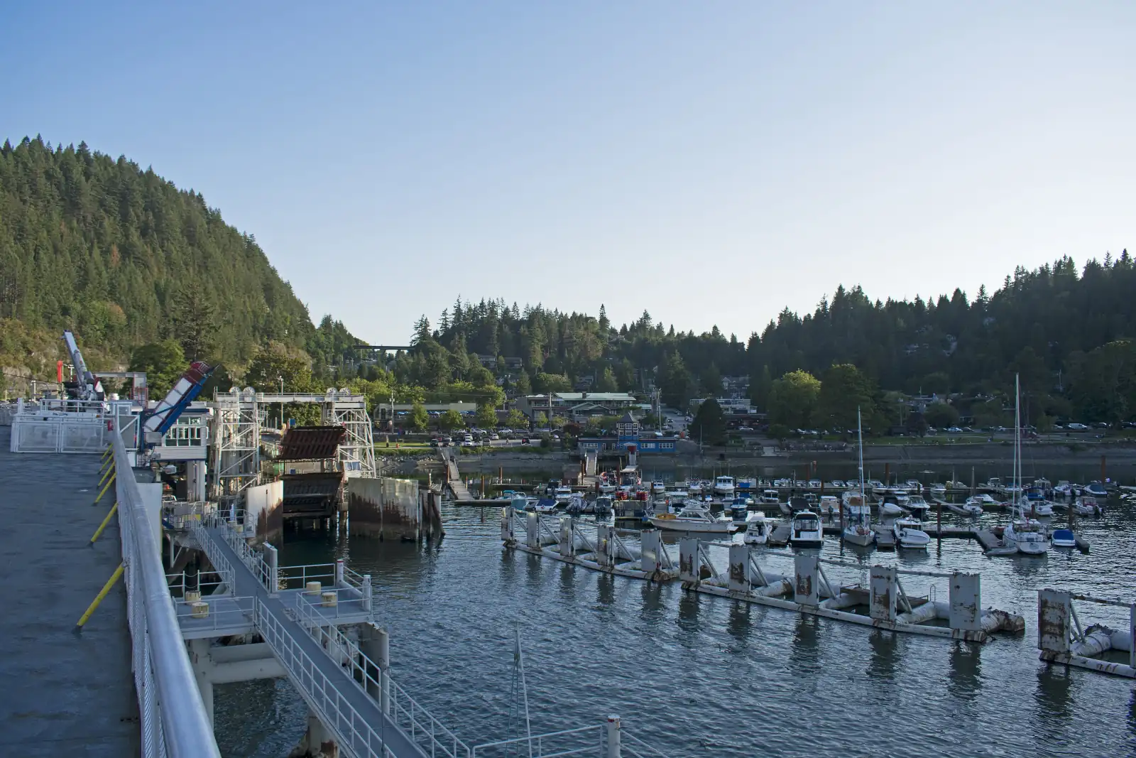
Photo: Ymblanter, Wikimedia Commons, CC BY-SA 4.0
Horseshoe Bay, Whytecliff and Eagleridge are in the District of West Vancouver. The province's boundary data also places Seascape Drive, Seascape Court and Bedora Place, the Howe Sound streets with homes listed on October 9, 2026, inside the District. The District ends 0.9 km north of Bedora Place. Past that line Metro Vancouver acts as the local government until the Village of Lions Bay begins, so read the municipality line on every Howe Sound listing.
What Horseshoe Bay is like
Horseshoe Bay is at the western end of West Vancouver. The province's place name record describes the bay as facing Queen Charlotte Channel in Howe Sound. Bay Street, Bruce Street and Royal Avenue are the central streets of the village, and Nelson Avenue leads south to Marine Drive. The District says Horseshoe Bay Park has a marina on its north side and the ferry terminal on its east side.
MLS® listings use four area names for the homes on this page. Horseshoe Bay WV is the village around the bay. Whytecliff is the community to the west, beside Whytecliff Park, where Cliff Road and Arbutus Road are. Eagleridge is named for Eagleridge Drive, which lies between Marine Drive and the highway, 1.4 km south of the village. Howe Sound covers homes further north along the Sea to Sky Highway. Its streets with listings on October 9, 2026 were Seascape Drive, Seascape Court and Bedora Place, beside Ansell Place and 3.4 km from the village in a straight line. The real estate board sets the lines between the four names, and we found no public street list for them, so read the area name printed on each listing.
Residents share the village with travellers bound for Nanaimo, the Sunshine Coast and Bowen Island. In our experience, the streets near the terminal are busiest on summer weekends and calm on a winter weekday. In our view, Horseshoe Bay suits a buyer who wants cafes, a waterfront park and a fast bus to downtown within a walk. A buyer who wants a large lot on a quiet street will find Gleneagles or Caulfeild a closer match.
Live from the MLS® system
Homes for sale in Horseshoe Bay
25 houses, townhouses and duplex homes are listed for sale in Horseshoe Bay today, checked against the MLS® system within the last hour. Condos and apartments are not shown on this page.


Prices
What a home in Horseshoe Bay costs
Two kinds of numbers, kept apart. The dots are asking prices of the homes listed in Horseshoe Bay today, counted on this page. The cards are Greater Vancouver REALTORS benchmark prices for all of West Vancouver, which describe a typical home sold anywhere in West Vancouver.
Asking prices today
Each dot is one home for sale. The dark line marks the middle price.
Detached house
$2,822,900
- One year
- down 9.9%
- Ten years
- down 21.9%
West Vancouver benchmark, Greater Vancouver REALTORS, September 2026
All home types
$2,244,700
- One year
- down 7.4%
- Ten years
- down 26.7%
West Vancouver benchmark, Greater Vancouver REALTORS, September 2026
Greater Vancouver REALTORS published no West Vancouver townhouse benchmark in its September 2026 report, so none is shown.
What the homes are like
On October 9, 2026, 72% of the homes listed in this area were detached houses, 16% were townhouses and 12% were duplex homes. Condo apartments are sold in the village too, and this page leaves them out. Streets with homes for sale that day included Marine Drive, Nelson Avenue, Bruce Street, Wellington Avenue, Rosebery Avenue and Madrona Crescent, as well as Cliff Road in Whytecliff and the three Howe Sound streets named above.
The houses listed here were older and smaller than the ones listed in Caulfeild that day. The middle house was finished in 1964 and had 2,634 square feet of floor area and three or four bedrooms, on a lot of 7,800 square feet, which is 0.18 of an acre. The middle Caulfeild house was finished in 1985 and had 3,531 square feet on 0.30 of an acre. Among the homes of all three types that stated a year, one in four was finished before 1960, one in four in the 1980s and one in four in 2000 or later. The townhouses were the newest group, with a middle year between 2006 and 2007, and the duplex homes had a middle year of 1993.
A view was mentioned in 64% of the listing descriptions, and waterfront in one in five. Few house listings state a suite: 72% left the suite line blank, 22% said the house had none, and a single listing stated a legal suite. The District treats a suite as legal when it meets the BC Building Code, is registered with the municipality and holds a licence for its use.
When the homes were built
Year built of the 24 listings that state it.
- Before 19606
- 1960s4
- 1970s1
- 1980s6
- 1990s1
- 2000s4
- 2020 and later2
Bedrooms
Bedrooms in the 25 listings that state it.
- 1 or 21
- 312
- 47
- 53
- 6 or more2
Suites: of the 5 houses for sale whose listing states it, 1 list a legal or licensed suite, 0 list a suite the municipality has not approved, and 4 list none. The rest leave the field blank.
The homes listed today have been on the market for 48 days at the middle, counted from each listing date to today. That is how long they have waited so far, which is a different number from how long homes take to sell.
Horseshoe Bay on the map
- Home for sale
- Public school
- Park
History
From Ch'axáý to White Cliff City to Horseshoe Bay
The District of West Vancouver states that it is on the traditional and unceded territories of the Squamish, Tsleil-Waututh and Musqueam Nations. The province's place name record gives the Squamish name for Horseshoe Bay, spelled Ch'axáý on a Highway 99 sign that the record quotes. A website of the Squamish and Lil'wat Nations, cited in the record, says the name refers to the sizzling sound that herring made when they spawned here in large numbers. The local public school carries the name as Gleneagles Ch'axáý Elementary.
The record says a survey plan dated May 1892 labelled the water "Horse Shoe Bay". A British navy survey had named the point to the west White Cliff Point, for its weathered white cliffs. In 1909, Sir Charles Tupper and Colonel Albert Whyte opened a townsite here called White Cliff City, and a book quoted in the record says that in 1914 Colonel Whyte had the railway station named Whytecliff, spelled like his own name. On July 28, 1945, the province made Horseshoe Bay the settlement's official name, which its record calls the preferred local name. Whytecliff was adopted for the community west of the bay on July 15, 1983.
The District's history page says only a few families lived in Horseshoe Bay all year before 1931, when Dan Sewell opened a marina and Whytecliff Lodge. Car ferries arrived twenty years later. An article by Gary Little in the Squamish Chief dates the first Black Ball car ferry from Horseshoe Bay to Gibsons to August 11, 1951, and the first service to Departure Bay in Nanaimo to 1953. It says the provincial Cabinet approved the purchase of the Black Ball ferries and terminals on November 30, 1961.
Daily life
Daily life in Horseshoe Bay
People who live near the bay can walk to coffee, a meal and basic groceries. The counts on this page show the cafes, the grocery store and the pharmacy mapped inside the area, all within 300 metres of the centre of the village. In our experience, residents do a larger shop at Caulfeild Village or at Park Royal. The 262 bus is given 8 minutes from the ferry terminal stop to Caulfeild Village, and the 257 express between 17 and 21 minutes to Park Royal.
The closest community centre is Gleneagles Community Centre, south of the village, where the District lists a fitness centre, a sports gym, a pottery studio and an art studio. The nearest library is the West Vancouver Memorial Library, and the table on this page gives the distance.
The ferry terminal affects daily life. BC Ferries sails from here to Nanaimo, the Sunshine Coast and Bowen Island, and its terminal parking holds 598 cars. The District warns that parking beside Horseshoe Bay Park fills quickly, most of all on weekends. On the Howe Sound streets the nearest shops are those in the village. The 262 bus stops on the highway ramps there once an hour, 6 minutes from the ferry terminal stop. In our experience, a household there needs a car.
Grocery stores
- Bay Market130 m
Cafes
- Seaside Village170 m
- Goldie's Donuts and Bakery200 m
- Starbucks220 m
- The Lookout Café260 m
- Blenz300 m
Libraries and rec centres
Nearest: Gleneagles Community Centre, 1.1 km away.
How far it is
- Downtown Vancouver (Waterfront Station)15.4 km
- Lonsdale Quay and the SeaBus15.7 km
- Lions Gate Hospital16.3 km
- Park Royal shopping centre11.3 km
Places from OpenStreetMap, read October 10, 2026. Distances are in a straight line from the middle of the area, so the trip by road is longer.
Outdoors
Horseshoe Bay Park, Whytecliff Park and the trails
Horseshoe Bay Park is the village waterfront. The District describes a one hectare park with a playground, a spray park, a pier and picnic tables. In the copy of the District's page saved in August 2025, the washrooms are open all year from 7 a.m. to 9 p.m., and dogs on a leash may use the paved footpaths.
Whytecliff Park is at the end of the 7000 block of Marine Drive, west of the village. The District gives its size as more than 15 hectares and lists a playground, a picnic shelter, a swimming beach in a protected bay, short trails and free public tennis courts. The water off the park is a scuba diving site, and the District calls it a Saltwater Marine Protected Area. Fisheries and Oceans Canada lists Whytecliff Park as closed to fishing by any gear or method all year. Pay parking applies all year from 7 a.m. to 10 p.m., and the District's page, as saved in August 2025, says a West Vancouver resident can apply for a yearly pass at no cost.
Two longer walks start nearby. Seaview Walk is an easy path of 4 km there and back, which the District says is suitable for wheelchairs, with an entrance across from Gleneagles Golf Course on Marine Drive. The Whyte Lake Trail starts on Westport Road, and the District calls it a two hour hike past old cedar and fir trees. The map on this page also marks Tantalus Park, Batchelor Bay Park and Garrow Bay Park.
Schools
Schools in and near Horseshoe Bay
Horseshoe Bay is served by West Vancouver Schools (School District 45). Gleneagles Ch'axáý Elementary, at 6350 Marine Drive, is the public elementary school closest to the middle of the area and teaches Kindergarten to Grade 7.
Rockridge Secondary, on Headland Drive across from Caulfeild Village, teaches Grades 8 to 12. The district says its families come from Bowen Island, West Bay, Caulfeild, Gleneagles and Lions Bay. Every student in Grades 8 to 10 takes the International Baccalaureate Middle Years Programme, a course of study taught in many countries, and the school offers Advanced Placement courses in Grades 11 and 12. For French immersion, the district lists École Pauline Johnson and École Cedardale for the elementary grades and Sentinel Secondary for high school, all further east.
The public school a child may attend depends on the home address. The district draws an area around each school, called a catchment, and it can differ from the nearest school. This matters most for a Howe Sound address, because the district's list also includes Lions Bay Community School to the north. On October 10, 2026, the district's website said admissions would open on October 15, 2026. Enter any address in the district's school locator, linked on this page, before you offer.
| School | Type | French programs | Distance |
|---|---|---|---|
Gleneagles Elementary 6350 Marine Dr, West Vancouver, BC | Public, elementary | None listed | 620 m |
Eagle Harbour Montessori 5575 Marine Dr, West Vancouver, BC | Public, elementary | None listed | 2.6 km |
Caulfeild Elementary 4685 Keith Rd, West Vancouver, BC | Public, elementary | None listed | 3.8 km |
Cypress Park Primary 4355 Marine Dr, West Vancouver, BC | Public, elementary | None listed | 4.6 km |
Rockridge Secondary 5350 Headland Dr, West Vancouver, BC | Public, secondary | None listed | 3.3 km |
West Vancouver Secondary 1750 Mathers Ave, West Vancouver, BC | Public, secondary | None listed | 9.3 km |
Mulgrave School 2330 Cypress Bowl Lane, West Vancouver, BC | Independent, elementary-secondary | None listed | 6.6 km |
Collingwood School 70 Morven Dr, West Vancouver, BC | Independent, elementary-secondary | None listed | 7.3 km |
St. Anthony's 595 Keith Rd, West Vancouver, BC | Independent, elementary | None listed | 11.5 km |
Bodwell High School 955 Harbourside Drive, North Vancouver, BC | Independent, secondary | None listed | 14.4 km |
Your address decides your assigned school, which can differ from the closest one. Check any address with the West Vancouver Schools school locator. School list from the BC Ministry of Education, updated October 8, 2026.
Getting around
Getting around
Two highways begin here. The province's list of numbered routes says Highway 1 starts at the Horseshoe Bay ferry terminal and runs east across the North Shore, where the District calls it the Upper Levels Highway. The Sea to Sky Highway (Highway 99) leaves it at exit 1 and follows Howe Sound north. Exit numbers on Highway 1 count the kilometres east of Horseshoe Bay: Eagleridge Drive is exit 2A, Caulfeild is exit 4, and Taylor Way, the turn for the Lions Gate Bridge, is exit 13.
The 257 express is the fast bus. In TransLink's schedule for September 7, 2026 to January 3, 2027, it leaves the stop on Keith Road at the ferry terminal 52 times on a weekday, from 5:50 a.m. to 12:20 a.m. Buses that leave between 7:13 and 8:40 a.m. are given between 33 and 37 minutes to West Georgia Street at Burrard Street. The 250 follows Marine Drive through Gleneagles, Caulfeild and Dundarave and is given 50 minutes to the same stop. The 262 runs once an hour, south to Caulfeild Village and north along the Sea to Sky Highway to Lions Bay.
The ferries are transport for residents too. A person who lives in the village can walk onto a ferry to Bowen Island, the Sunshine Coast or Nanaimo. For drivers, BC Ferries describes the terminal as a 25 minute drive from downtown Vancouver.
Routes that stop in Horseshoe Bay
Trips on a regular weekday that stop at one of the 10 stops inside the area, from TransLink's published schedule valid to January 3, 2027.
- 257Horseshoe Bay/Vancouver Express104 trips
- 250Horseshoe Bay/Dundarave/Vancouver95 trips
- 262Lions Bay/Caulfeild38 trips
Before you buy
Things to check in Horseshoe Bay
Ferry traffic near the terminal
BC Ferries says every vehicle going to Nanaimo must be booked and paid for in advance, and that vehicles for Langdale and Bowen Island without a booking board in the order they arrive. In our experience, drivers arrive early and wait. For a home close to the terminal or the highway, visit on a Friday afternoon in summer, listen from the garden, and check where guests would park.
Homes on the shore
On April 11, 2022, the District adopted a Foreshore permit area to lower the risk from a rising sea, storms and flooding. Inside it, new living space on a lot that could flood from the sea must be raised to a set flood level, and work within 15 metres of the high tide line needs a permit. The Foreshore layer on WestMap, the District's online map, shows which lots are inside.
Forest edge and the wildfire map
The District's Wildfire Hazard permit area, approved on December 14, 2020, takes in every property within 100 metres of a forested area. The District says wildfires burned at Whyte Lake and in Lions Bay in 2018. Inside the area, a new or replacement house needs a wildfire permit and a report from a qualified professional. Check the address on WestMap and phone an insurer before your offer becomes firm.
Rock, slopes and creeks
The District describes the coast at Whytecliff Park as rugged. On a sloped lot, walk the driveway, look at the walls that hold back the soil, and ask for any engineer's report. The map shows Larson Creek south of the village. The District requires a permit for work within 15 metres of the top of a creek bank.
A Howe Sound address
The Howe Sound streets listed on October 9, 2026 are inside the District of West Vancouver. Further north, Metro Vancouver names Ocean Point, Strachan Point and Montizambert Wynd as communities in Electoral Area A, where it acts as the local government. Read the municipality line on the listing, confirm it on the property tax notice, and ask about the school catchment.
Older houses and suites
The middle house listed here on October 9, 2026 was finished in 1964. Ask for a dated list of what has been replaced, such as the roof, the windows, the wiring and the heating. If the house has a suite, ask for the District's registration and the current licence. The District's page, as saved in August 2025, lists fines of up to $10,000 for a suite left unregistered.
Buying
Buying a home in Horseshoe Bay
Start by choosing one of four places. A home in the village is a walk from the shops, the park and the express bus, and it is the closest to the ferry terminal. Whytecliff is less than a kilometre west, beside the larger park. Eagleridge has its own highway exit and is next to Gleneagles. The Howe Sound streets are a drive up the Sea to Sky Highway. The price dots on this page show today's asking prices for all four together.
Read five lines on each listing before you book a visit: the area name, the municipality, the home type, the year the home was finished and the suite line. If the home is a townhouse or a duplex home, ask whether it is part of a strata, which is a group of owners who share some costs and rules, and read the strata's papers with your lawyer or notary. Visit once on a summer Friday afternoon and once on a weekday morning to try the 257 or the drive.
Michael Lee works with buyers in Horseshoe Bay and across West Vancouver. Send him the form on this page with your budget, and say which of the four places you prefer and whether you need a suite or a view. He will reply with the homes that match and times to see them.
Selling
Selling a home in Horseshoe Bay
In our experience, five things decide the price of a home here: whether it is on the water, the view, the distance from the ferry terminal and the highway, the age and condition of the home, and the slope of the lot. Gather the papers a careful buyer will ask for before you list. These are the District's records for past work, any permit for work near the shore or a creek, any engineer's report on the slope, and the registration and licence for a suite.
Real estate board rules limit who may see sold prices, so this page shows asking prices only. Michael Lee can go through recent sales near you in a private meeting and suggest a list price. To begin, choose "What is my home worth?" on the form on this page.
Houses listed
18
$1.25M to $7.50M
Townhouses listed
4
$1.69M to $1.90M
Duplex homes listed
3
$1.63M to $2.00M
Our view
Who buys in Horseshoe Bay
In our experience, three groups buy in the village. The first wants to walk to a waterfront, cafes and an express bus. The second is owners of larger West Vancouver houses who move to a townhouse or a duplex home for less upkeep. The third has family or a second home on Bowen Island, the Sunshine Coast or Vancouver Island and values living beside the ferry.
Whytecliff and the Howe Sound streets attract a different buyer, in our experience: someone who wants a view over the water and a quiet street, and who drives for errands.
Horseshoe Bay and the areas next to it
Homes listed for sale today, counted on this page.
| Area | For sale | Middle asking price | Houses, middle price |
|---|---|---|---|
| Horseshoe Bay | 25 | $2.00M | $2.40M |
| Gleneagles | 7 | $4.31M | $4.31M |
| Eagle Harbour | 14 | $2.48M | $2.48M |
| Caulfeild | 33 | $3.25M | $3.42M |
Questions about Horseshoe Bay
Is Horseshoe Bay in the City or the District of West Vancouver?
Horseshoe Bay is in the District of West Vancouver. West Vancouver has one municipality, incorporated on March 15, 1912, so there is no separate city. Tax bills and local rules for every village address come from the District.
Which MLS® areas does this Horseshoe Bay page cover?
It covers four MLS® area names. Horseshoe Bay WV is the village around the bay. Whytecliff is the community to the west, beside Whytecliff Park. Eagleridge is the streets around Eagleridge Drive, south of the village. Howe Sound covers homes further north along the Sea to Sky Highway.
Are homes listed under Howe Sound inside West Vancouver?
The Howe Sound streets with listings on October 9, 2026 were Seascape Drive, Seascape Court and Bedora Place, and the province's boundary data places all three inside the District. The District ends 0.9 km north of Bedora Place, so read the municipality line on each listing.
What kind of homes are for sale in Horseshoe Bay?
Mostly detached houses. On October 9, 2026, 72% of the homes listed were houses, 16% were townhouses and 12% were duplex homes. The middle house had 2,634 square feet of floor area on a lot of 0.18 of an acre. This page leaves out condo apartments.
How much does a house in Horseshoe Bay cost?
The price dots on this page mark the asking price of every home listed today, with the middle price shown. The page also shows the benchmark price for a detached house in West Vancouver, which Greater Vancouver REALTORS publishes each month as the price of a typical house.
Which ferries leave from Horseshoe Bay?
BC Ferries sails from Horseshoe Bay to Departure Bay in Nanaimo, to Langdale on the Sunshine Coast and to Snug Cove on Bowen Island. The terminal is at 6750 Keith Road. Every vehicle going to Nanaimo must be booked and paid for in advance.
How long is the bus ride from Horseshoe Bay to downtown Vancouver?
TransLink's fall 2026 schedule gives the 257 express between 33 and 37 minutes from the ferry terminal stop to West Georgia Street at Burrard Street, for weekday buses that leave between 7:13 and 8:40 a.m. The 250, which follows Marine Drive, is given 50 minutes.
Which schools serve Horseshoe Bay?
Horseshoe Bay is in West Vancouver Schools (School District 45). Gleneagles Ch'axáý Elementary on Marine Drive teaches Kindergarten to Grade 7, and Rockridge Secondary on Headland Drive teaches Grades 8 to 12. The district's French immersion schools are further east. Check any address in the district's school locator.
How did Horseshoe Bay and Whytecliff get their names?
The province's place name record says "Horse Shoe Bay" appears on a survey plan of May 1892. Whytecliff comes from White Cliff Point and from Colonel Albert Whyte, who helped open a townsite here in 1909. The settlement's official name became Horseshoe Bay on July 28, 1945.
Can you swim, dive or fish at Whytecliff Park?
You can swim and dive. The District lists a swimming beach in a protected bay and a ramp for divers with disabilities. Fishing is closed all year, by any gear or method, under a Fisheries and Oceans Canada closure. Pay parking applies all year, and a West Vancouver resident can apply for a pass at no cost.
Are there wildfire, shore or creek rules for homes in Horseshoe Bay?
Yes. The District's Wildfire Hazard area, approved in 2020, covers lots within 100 metres of forest. Its Foreshore area, adopted in 2022, sets a flood level for new living space on lots that could flood from the sea. Work within 15 metres of a creek bank also needs a permit. WestMap shows the wildfire and Foreshore areas.
How do I find out what my Horseshoe Bay home is worth?
Pick "What is my home worth?" in the form on this page. Michael Lee will compare your home with recent sales of similar homes nearby and tell you the price he would list at. He shares sold prices in private, because real estate board rules limit who may see them.
Who should I talk to about buying or selling in Horseshoe Bay?
Speak with Michael Lee, REALTOR®, Personal Real Estate Corporation, with eXp Realty, who handles West Vancouver for MultiLiving. Phone him at 604-803-9863 or send the form on this page, and say whether your interest is the village, Whytecliff, Eagleridge or Howe Sound.
Sources
Written content checked October 10, 2026. Listing numbers counted from the MLS® system on October 12, 2026.
- Horseshoe Bay (community): location, name changes and origin notes, BC Geographical Names, Government of British Columbia. Read October 10, 2026.
- Horseshoe Bay (bay): location, adoption date, 1892 survey plan and Squamish name, BC Geographical Names, Government of British Columbia. Read October 10, 2026.
- Whytecliff (community): location, adoption date and origin notes, BC Geographical Names, Government of British Columbia. Read October 10, 2026.
- White Cliff Point: origin notes, BC Geographical Names, Government of British Columbia. Read October 10, 2026.
- West Vancouver: Yesterday and Today (archived copy of November 4, 2025), District of West Vancouver. Read October 10, 2026.
- Black Ball Ferries transformed Coast 70 years ago this month, by Gary Little, August 6, 2021 (archived copy of December 7, 2024), Squamish Chief. Read October 10, 2026.
- Horseshoe Bay Park (archived copy of August 17, 2025), District of West Vancouver. Read October 10, 2026.
- Whytecliff Park (archived copy of February 9, 2026), District of West Vancouver. Read October 10, 2026.
- Area 28 (Vancouver, Howe Sound) recreational fishing: Whytecliff Park closure, Fisheries and Oceans Canada. Read October 10, 2026.
- Destination Parks Pay Parking (archived copy of August 1, 2025), District of West Vancouver. Read October 10, 2026.
- Seaview Walk (archived copy of August 17, 2025), District of West Vancouver. Read October 10, 2026.
- Whyte Lake Park (archived copy of June 9, 2026), District of West Vancouver. Read October 10, 2026.
- Gleneagles Community Centre (archived copy of August 5, 2025), District of West Vancouver. Read October 10, 2026.
- Foreshore Development Permits (archived copy of August 5, 2025), District of West Vancouver. Read October 10, 2026.
- Wildfire Hazard Development Permits (archived copy of August 5, 2025), District of West Vancouver. Read October 10, 2026.
- Environmental Development Permits: creeks (archived copy of August 11, 2025), District of West Vancouver. Read October 10, 2026.
- Secondary Suites (archived copy of August 15, 2025), District of West Vancouver. Read October 10, 2026.
- Vancouver (Horseshoe Bay) terminal: address, routes, bookings, parking and connections, BC Ferries. Read October 10, 2026.
- Official Numbered Routes in British Columbia (last updated March 19, 2026), Government of British Columbia. Read October 10, 2026.
- Highway exits: Sea-to-Sky Highway 99 and Trans-Canada Highway 1 (last updated November 7, 2025), Government of British Columbia. Read October 10, 2026.
- Municipalities: Legally Defined Administrative Areas of BC (boundary of the District of West Vancouver and the Village of Lions Bay), Government of British Columbia, through the BC Data Catalogue. Read October 10, 2026.
- Electoral Area A (Howe Sound communities and local government), Metro Vancouver. Read October 10, 2026.
- Primary and elementary schools, West Vancouver Schools. Read October 10, 2026.
- Secondary schools, West Vancouver Schools. Read October 10, 2026.
- Gleneagles Ch'axáý, West Vancouver Schools. Read October 10, 2026.
- Rockridge, West Vancouver Schools. Read October 10, 2026.
- Positions of streets, highways and creeks around Horseshoe Bay, read through the Overpass API, OpenStreetMap contributors (Open Database License). Read October 10, 2026.
- TransLink schedule data (GTFS), in effect September 7, 2026 to January 3, 2027, TransLink. Read October 10, 2026.
- MLS® Home Price Index, September 2026 stats package, Greater Vancouver REALTORS. Read October 9, 2026.
- K-12 school locations (school names, addresses and programs), BC Ministry of Education and Child Care, through the BC Data Catalogue. Read October 9, 2026.
- Places, parks and shops, OpenStreetMap contributors (Open Database License). Read October 9, 2026.
- Bus, SeaBus and train schedules (GTFS feed 26SEP_20261009), TransLink. Read October 9, 2026.
General information only. The prices, benchmarks, strata rules, tax and fee figures, lease terms, permit rules and school details on this page are based on the sources and dates listed above. They are not financial, mortgage, tax or legal advice, and not a guarantee of any outcome. Prices, tax rates, fees, municipal rules and school catchments change. Before you buy or sell, confirm each one with its source and speak with a licensed REALTOR®, a mortgage broker and a real estate lawyer.